You are here: Home > Network List > IW - Intermountain West Stations List
> Station MOOW Moose Ponds, Wyoming, USA > Earthquake Result Viewer
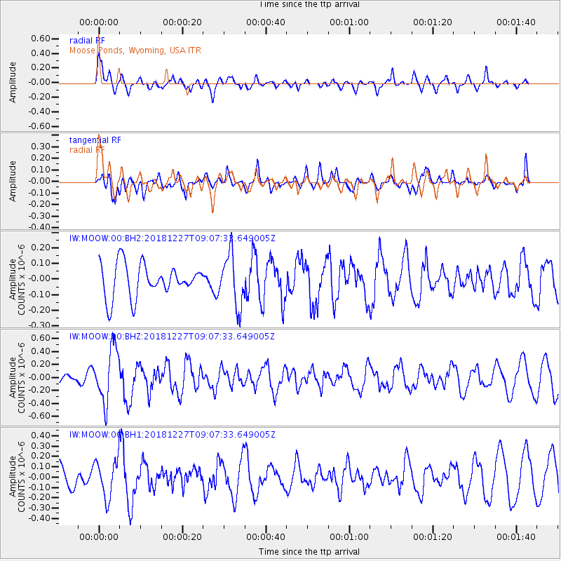
MOOW Moose Ponds, Wyoming, USA - Earthquake Result Viewer
*The percent match for this event was below the threshold and hence no stack was calculated.
| Earthquake location: |
Near Coast Of Venezuela |
| Earthquake latitude/longitude: |
10.3/-67.9 |
| Earthquake time(UTC): |
2018/12/27 (361) 08:59:11 GMT |
| Earthquake Depth: |
10 km |
| Earthquake Magnitude: |
5.6 Mww |
| Earthquake Catalog/Contributor: |
NEIC PDE/us |
|
| Network: |
IW Intermountain West |
| Station: |
MOOW Moose Ponds, Wyoming, USA |
| Lat/Lon: |
43.75 N/110.74 W |
| Elevation: |
2128 m |
|
| Distance: |
49.8 deg |
| Az: |
319.843 deg |
| Baz: |
118.866 deg |
| Ray Param: |
$rayparam |
*The percent match for this event was below the threshold and hence was not used in the summary stack. |
|
| Radial Match: |
71.79979 % |
| Radial Bump: |
400 |
| Transverse Match: |
60.758385 % |
| Transverse Bump: |
400 |
| SOD ConfigId: |
3201911 |
| Insert Time: |
2019-01-10 09:16:11.894 +0000 |
| GWidth: |
2.5 |
| Max Bumps: |
400 |
| Tol: |
0.001 |
|
Signal To Noise
| Channel | StoN | STA | LTA |
| IW:MOOW:00:BHZ:20181227T09:07:33.649005Z | 3.365652 | 4.248824E-7 | 1.2624074E-7 |
| IW:MOOW:00:BH1:20181227T09:07:33.649005Z | 1.972172 | 1.8825463E-7 | 9.545548E-8 |
| IW:MOOW:00:BH2:20181227T09:07:33.649005Z | 1.6045897 | 1.6962272E-7 | 1.0571096E-7 |
| Arrivals |
| Ps | |
| PpPs | |
| PsPs/PpSs | |


