You are here: Home > Network List > YN10 - San Jacinto Fault Zone Stations List
> Station JORD JORD > Earthquake Result Viewer
JORD JORD - Earthquake Result Viewer
| Earthquake location: |
Kuril Islands |
| Earthquake latitude/longitude: |
50.7/156.3 |
| Earthquake time(UTC): |
2023/09/01 (244) 20:49:54 GMT |
| Earthquake Depth: |
141 km |
| Earthquake Magnitude: |
6.1 Mww |
| Earthquake Catalog/Contributor: |
NEIC PDE/us |
|
| Network: |
YN San Jacinto Fault Zone |
| Station: |
JORD JORD |
| Lat/Lon: |
33.47 N/116.64 W |
| Elevation: |
1235 m |
|
| Distance: |
63.2 deg |
| Az: |
69.28 deg |
| Baz: |
314.638 deg |
| Ray Param: |
0.059337962 |
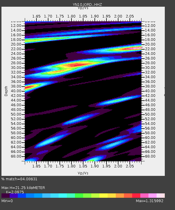
| Estimated Moho Depth: |
21.25 km |
| Estimated Crust Vp/Vs: |
2.10 |
| Assumed Crust Vp: |
6.264 km/s |
| Estimated Crust Vs: |
2.986 km/s |
| Estimated Crust Poisson's Ratio: |
0.35 |
|
| Radial Match: |
84.08631 % |
| Radial Bump: |
400 |
| Transverse Match: |
63.98061 % |
| Transverse Bump: |
400 |
| SOD ConfigId: |
31937991 |
| Insert Time: |
2023-09-15 21:33:51.456 +0000 |
| GWidth: |
2.5 |
| Max Bumps: |
400 |
| Tol: |
0.001 |
|

Signal To Noise
| Channel | StoN | STA | LTA |
| YN:JORD: :HHZ:20230901T20:59:37.189991Z | 6.3740425 | 1.4496421E-6 | 2.27429E-7 |
| YN:JORD: :HHN:20230901T20:59:37.189991Z | 2.2521198 | 5.3794537E-7 | 2.388618E-7 |
| YN:JORD: :HHE:20230901T20:59:37.189991Z | 2.201802 | 4.0390273E-7 | 1.834419E-7 |
| Arrivals |
| Ps | 3.9 SECOND |
| PpPs | 10 SECOND |
| PsPs/PpSs | 14 SECOND |


