You are here: Home > Network List > TA - USArray Transportable Network (new EarthScope stations) Stations List
> Station D26A Manning, ND, USA > Earthquake Result Viewer
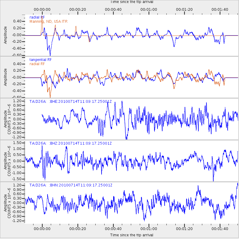
D26A Manning, ND, USA - Earthquake Result Viewer
*The percent match for this event was below the threshold and hence no stack was calculated.
| Earthquake location: |
Andreanof Islands, Aleutian Is. |
| Earthquake latitude/longitude: |
51.8/-176.1 |
| Earthquake time(UTC): |
2010/07/14 (195) 11:01:27 GMT |
| Earthquake Depth: |
51 km |
| Earthquake Magnitude: |
5.6 MB, 5.6 MW, 4.9 ML |
| Earthquake Catalog/Contributor: |
WHDF/NEIC |
|
| Network: |
TA USArray Transportable Network (new EarthScope stations) |
| Station: |
D26A Manning, ND, USA |
| Lat/Lon: |
47.03 N/102.44 W |
| Elevation: |
693 m |
|
| Distance: |
46.3 deg |
| Az: |
65.288 deg |
| Baz: |
304.469 deg |
| Ray Param: |
$rayparam |
*The percent match for this event was below the threshold and hence was not used in the summary stack. |
|
| Radial Match: |
67.81828 % |
| Radial Bump: |
400 |
| Transverse Match: |
61.1348 % |
| Transverse Bump: |
400 |
| SOD ConfigId: |
319893 |
| Insert Time: |
2011-01-05 03:54:47.700 +0000 |
| GWidth: |
2.5 |
| Max Bumps: |
400 |
| Tol: |
0.001 |
|
Signal To Noise
| Channel | StoN | STA | LTA |
| TA:D26A: :BHZ:20100714T11:09:17.25001Z | 2.1392379 | 6.446155E-7 | 3.0132952E-7 |
| TA:D26A: :BHN:20100714T11:09:17.25001Z | 1.026303 | 3.9330965E-7 | 3.8322955E-7 |
| TA:D26A: :BHE:20100714T11:09:17.25001Z | 1.7422174 | 5.407329E-7 | 3.103705E-7 |
| Arrivals |
| Ps | |
| PpPs | |
| PsPs/PpSs | |


