You are here: Home > Network List > US - United States National Seismic Network Stations List
> Station CBKS Cedar Bluff, Kansas, USA > Earthquake Result Viewer
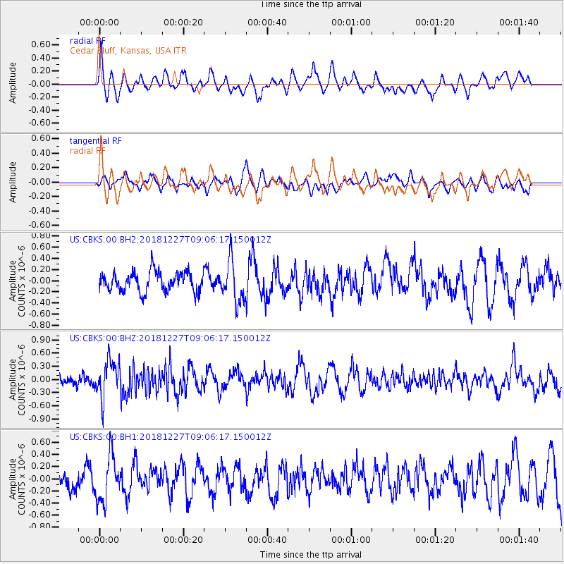
CBKS Cedar Bluff, Kansas, USA - Earthquake Result Viewer
*The percent match for this event was below the threshold and hence no stack was calculated.
| Earthquake location: |
Near Coast Of Venezuela |
| Earthquake latitude/longitude: |
10.3/-67.9 |
| Earthquake time(UTC): |
2018/12/27 (361) 08:59:11 GMT |
| Earthquake Depth: |
10 km |
| Earthquake Magnitude: |
5.6 Mww |
| Earthquake Catalog/Contributor: |
NEIC PDE/us |
|
| Network: |
US United States National Seismic Network |
| Station: |
CBKS Cedar Bluff, Kansas, USA |
| Lat/Lon: |
38.81 N/99.74 W |
| Elevation: |
677 m |
|
| Distance: |
40.2 deg |
| Az: |
320.325 deg |
| Baz: |
126.462 deg |
| Ray Param: |
$rayparam |
*The percent match for this event was below the threshold and hence was not used in the summary stack. |
|
| Radial Match: |
64.18961 % |
| Radial Bump: |
400 |
| Transverse Match: |
42.476913 % |
| Transverse Bump: |
400 |
| SOD ConfigId: |
3201911 |
| Insert Time: |
2019-01-10 09:18:18.695 +0000 |
| GWidth: |
2.5 |
| Max Bumps: |
400 |
| Tol: |
0.001 |
|
Signal To Noise
| Channel | StoN | STA | LTA |
| US:CBKS:00:BHZ:20181227T09:06:17.150012Z | 2.9856193 | 4.2879375E-7 | 1.436197E-7 |
| US:CBKS:00:BH1:20181227T09:06:17.150012Z | 1.6297383 | 3.8394387E-7 | 2.3558621E-7 |
| US:CBKS:00:BH2:20181227T09:06:17.150012Z | 2.190011 | 3.8135312E-7 | 1.7413296E-7 |
| Arrivals |
| Ps | |
| PpPs | |
| PsPs/PpSs | |


