You are here: Home > Network List > TA - USArray Transportable Network (new EarthScope stations) Stations List
> Station P34A Walnut Farm, Randolph, KS, USA > Earthquake Result Viewer
P34A Walnut Farm, Randolph, KS, USA - Earthquake Result Viewer
| Earthquake location: |
Andreanof Islands, Aleutian Is. |
| Earthquake latitude/longitude: |
51.8/-176.1 |
| Earthquake time(UTC): |
2010/07/14 (195) 11:01:27 GMT |
| Earthquake Depth: |
51 km |
| Earthquake Magnitude: |
5.6 MB, 5.6 MW, 4.9 ML |
| Earthquake Catalog/Contributor: |
WHDF/NEIC |
|
| Network: |
TA USArray Transportable Network (new EarthScope stations) |
| Station: |
P34A Walnut Farm, Randolph, KS, USA |
| Lat/Lon: |
39.55 N/96.83 W |
| Elevation: |
429 m |
|
| Distance: |
54.1 deg |
| Az: |
69.701 deg |
| Baz: |
311.144 deg |
| Ray Param: |
0.06554147 |
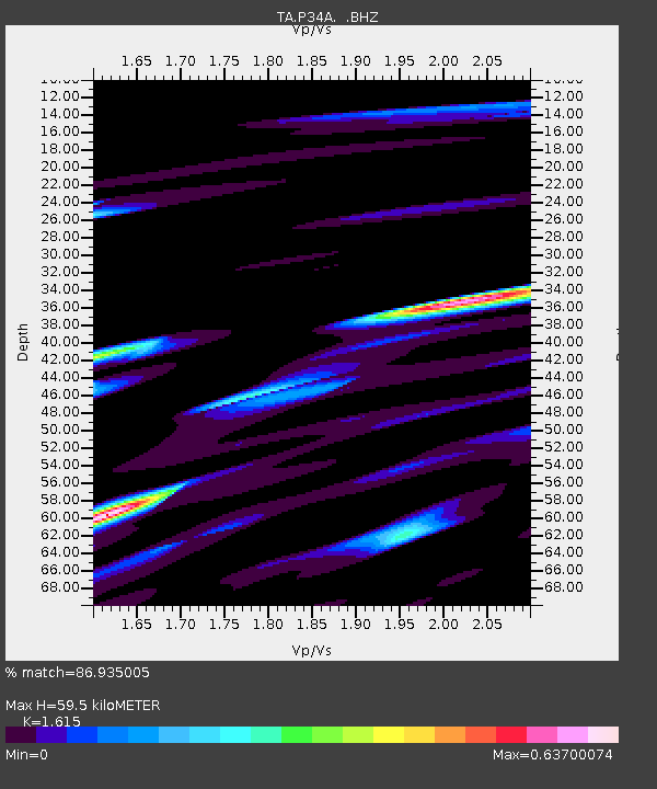
| Estimated Moho Depth: |
59.5 km |
| Estimated Crust Vp/Vs: |
1.62 |
| Assumed Crust Vp: |
6.483 km/s |
| Estimated Crust Vs: |
4.014 km/s |
| Estimated Crust Poisson's Ratio: |
0.19 |
|
| Radial Match: |
86.935005 % |
| Radial Bump: |
400 |
| Transverse Match: |
78.95356 % |
| Transverse Bump: |
400 |
| SOD ConfigId: |
319893 |
| Insert Time: |
2011-01-05 04:01:39.227 +0000 |
| GWidth: |
2.5 |
| Max Bumps: |
400 |
| Tol: |
0.001 |
|

Signal To Noise
| Channel | StoN | STA | LTA |
| TA:P34A: :BHZ:20100714T11:10:16.299998Z | 1.7430999 | 5.6866736E-7 | 3.262391E-7 |
| TA:P34A: :BHN:20100714T11:10:16.299998Z | 2.0924602 | 4.2031255E-7 | 2.0087003E-7 |
| TA:P34A: :BHE:20100714T11:10:16.299998Z | 5.213366 | 2.6151108E-7 | 5.0161656E-8 |
| Arrivals |
| Ps | 6.0 SECOND |
| PpPs | 23 SECOND |
| PsPs/PpSs | 29 SECOND |


