You are here: Home > Network List > US - United States National Seismic Network Stations List
> Station MIAR Mount Ida, Arkansas, USA > Earthquake Result Viewer
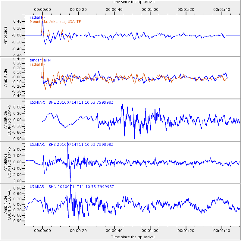
MIAR Mount Ida, Arkansas, USA - Earthquake Result Viewer
*The percent match for this event was below the threshold and hence no stack was calculated.
| Earthquake location: |
Andreanof Islands, Aleutian Is. |
| Earthquake latitude/longitude: |
51.8/-176.1 |
| Earthquake time(UTC): |
2010/07/14 (195) 11:01:27 GMT |
| Earthquake Depth: |
51 km |
| Earthquake Magnitude: |
5.6 MB, 5.6 MW, 4.9 ML |
| Earthquake Catalog/Contributor: |
WHDF/NEIC |
|
| Network: |
US United States National Seismic Network |
| Station: |
MIAR Mount Ida, Arkansas, USA |
| Lat/Lon: |
34.55 N/93.58 W |
| Elevation: |
207 m |
|
| Distance: |
59.4 deg |
| Az: |
71.972 deg |
| Baz: |
314.342 deg |
| Ray Param: |
$rayparam |
*The percent match for this event was below the threshold and hence was not used in the summary stack. |
|
| Radial Match: |
72.84885 % |
| Radial Bump: |
400 |
| Transverse Match: |
74.057434 % |
| Transverse Bump: |
400 |
| SOD ConfigId: |
319893 |
| Insert Time: |
2011-01-05 04:02:50.415 +0000 |
| GWidth: |
2.5 |
| Max Bumps: |
400 |
| Tol: |
0.001 |
|
Signal To Noise
| Channel | StoN | STA | LTA |
| US:MIAR: :BHZ:20100714T11:10:53.799998Z | 4.331797 | 7.046886E-7 | 1.6267812E-7 |
| US:MIAR: :BHN:20100714T11:10:53.799998Z | 1.8328736 | 2.5298192E-7 | 1.3802475E-7 |
| US:MIAR: :BHE:20100714T11:10:53.799998Z | 0.87529916 | 1.715658E-7 | 1.9600817E-7 |
| Arrivals |
| Ps | |
| PpPs | |
| PsPs/PpSs | |


