You are here: Home > Network List > US - United States National Seismic Network Stations List
> Station OXF Oxford, Mississippi, USA > Earthquake Result Viewer
OXF Oxford, Mississippi, USA - Earthquake Result Viewer
| Earthquake location: |
Andreanof Islands, Aleutian Is. |
| Earthquake latitude/longitude: |
51.8/-176.1 |
| Earthquake time(UTC): |
2010/07/14 (195) 11:01:27 GMT |
| Earthquake Depth: |
51 km |
| Earthquake Magnitude: |
5.6 MB, 5.6 MW, 4.9 ML |
| Earthquake Catalog/Contributor: |
WHDF/NEIC |
|
| Network: |
US United States National Seismic Network |
| Station: |
OXF Oxford, Mississippi, USA |
| Lat/Lon: |
34.51 N/89.41 W |
| Elevation: |
101 m |
|
| Distance: |
61.9 deg |
| Az: |
69.215 deg |
| Baz: |
315.342 deg |
| Ray Param: |
0.06049512 |
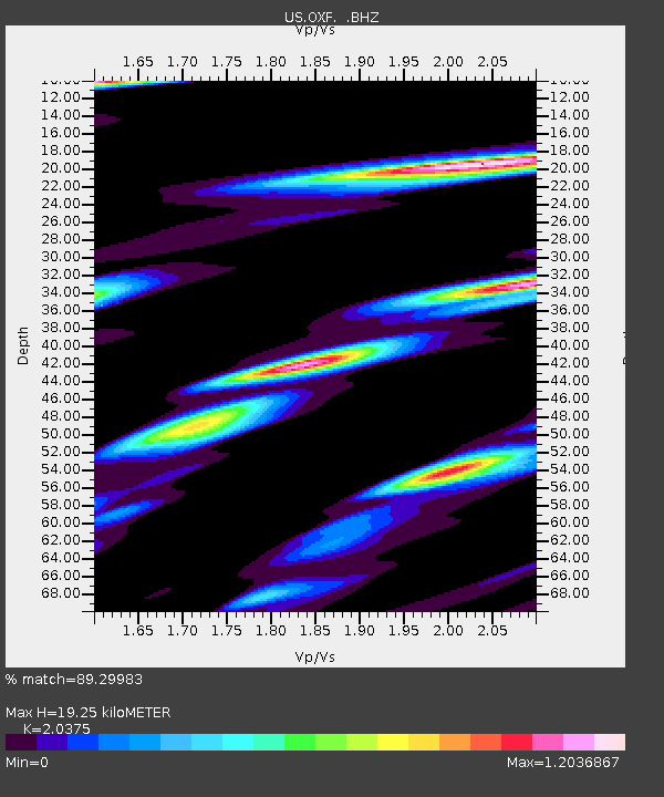
| Estimated Moho Depth: |
19.25 km |
| Estimated Crust Vp/Vs: |
2.04 |
| Assumed Crust Vp: |
6.38 km/s |
| Estimated Crust Vs: |
3.132 km/s |
| Estimated Crust Poisson's Ratio: |
0.34 |
|
| Radial Match: |
89.29983 % |
| Radial Bump: |
400 |
| Transverse Match: |
65.9611 % |
| Transverse Bump: |
400 |
| SOD ConfigId: |
319893 |
| Insert Time: |
2011-01-05 04:02:54.240 +0000 |
| GWidth: |
2.5 |
| Max Bumps: |
400 |
| Tol: |
0.001 |
|

Signal To Noise
| Channel | StoN | STA | LTA |
| US:OXF: :BHZ:20100714T11:11:10.524973Z | 8.47503 | 1.8055822E-6 | 2.1304729E-7 |
| US:OXF: :BHN:20100714T11:11:10.524973Z | 4.3199663 | 8.62502E-7 | 1.9965479E-7 |
| US:OXF: :BHE:20100714T11:11:10.524973Z | 2.5328128 | 6.4144473E-7 | 2.5325392E-7 |
| Arrivals |
| Ps | 3.3 SECOND |
| PpPs | 8.8 SECOND |
| PsPs/PpSs | 12 SECOND |


