You are here: Home > Network List > US - United States National Seismic Network Stations List
> Station BLA Blacksburg, Virginia, USA > Earthquake Result Viewer
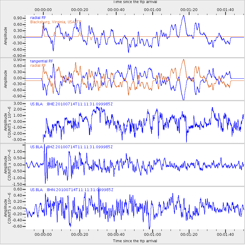
BLA Blacksburg, Virginia, USA - Earthquake Result Viewer
*The percent match for this event was below the threshold and hence no stack was calculated.
| Earthquake location: |
Andreanof Islands, Aleutian Is. |
| Earthquake latitude/longitude: |
51.8/-176.1 |
| Earthquake time(UTC): |
2010/07/14 (195) 11:01:27 GMT |
| Earthquake Depth: |
51 km |
| Earthquake Magnitude: |
5.6 MB, 5.6 MW, 4.9 ML |
| Earthquake Catalog/Contributor: |
WHDF/NEIC |
|
| Network: |
US United States National Seismic Network |
| Station: |
BLA Blacksburg, Virginia, USA |
| Lat/Lon: |
37.21 N/80.42 W |
| Elevation: |
634 m |
|
| Distance: |
65.0 deg |
| Az: |
61.245 deg |
| Baz: |
317.021 deg |
| Ray Param: |
$rayparam |
*The percent match for this event was below the threshold and hence was not used in the summary stack. |
|
| Radial Match: |
43.87201 % |
| Radial Bump: |
400 |
| Transverse Match: |
44.625675 % |
| Transverse Bump: |
400 |
| SOD ConfigId: |
319893 |
| Insert Time: |
2011-01-05 04:03:07.307 +0000 |
| GWidth: |
2.5 |
| Max Bumps: |
400 |
| Tol: |
0.001 |
|
Signal To Noise
| Channel | StoN | STA | LTA |
| US:BLA: :BHZ:20100714T11:11:31.099985Z | 3.6654816 | 6.330009E-7 | 1.7269244E-7 |
| US:BLA: :BHN:20100714T11:11:31.099985Z | 1.3265778 | 1.9060695E-7 | 1.4368321E-7 |
| US:BLA: :BHE:20100714T11:11:31.099985Z | 2.2927625 | 2.255058E-6 | 9.83555E-7 |
| Arrivals |
| Ps | |
| PpPs | |
| PsPs/PpSs | |


