You are here: Home > Network List > US - United States National Seismic Network Stations List
> Station EGMT Eagleton, Montana, USA > Earthquake Result Viewer
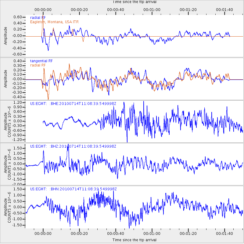
EGMT Eagleton, Montana, USA - Earthquake Result Viewer
*The percent match for this event was below the threshold and hence no stack was calculated.
| Earthquake location: |
Andreanof Islands, Aleutian Is. |
| Earthquake latitude/longitude: |
51.8/-176.1 |
| Earthquake time(UTC): |
2010/07/14 (195) 11:01:27 GMT |
| Earthquake Depth: |
51 km |
| Earthquake Magnitude: |
5.6 MB, 5.6 MW, 4.9 ML |
| Earthquake Catalog/Contributor: |
WHDF/NEIC |
|
| Network: |
US United States National Seismic Network |
| Station: |
EGMT Eagleton, Montana, USA |
| Lat/Lon: |
48.02 N/109.75 W |
| Elevation: |
1055 m |
|
| Distance: |
41.6 deg |
| Az: |
67.948 deg |
| Baz: |
301.002 deg |
| Ray Param: |
$rayparam |
*The percent match for this event was below the threshold and hence was not used in the summary stack. |
|
| Radial Match: |
30.452606 % |
| Radial Bump: |
400 |
| Transverse Match: |
34.650036 % |
| Transverse Bump: |
400 |
| SOD ConfigId: |
319893 |
| Insert Time: |
2011-01-05 04:04:28.203 +0000 |
| GWidth: |
2.5 |
| Max Bumps: |
400 |
| Tol: |
0.001 |
|
Signal To Noise
| Channel | StoN | STA | LTA |
| US:EGMT: :BHZ:20100714T11:08:39.549998Z | 3.0319757 | 5.1056554E-7 | 1.6839368E-7 |
| US:EGMT: :BHN:20100714T11:08:39.549998Z | 0.97672594 | 3.3555466E-7 | 3.435505E-7 |
| US:EGMT: :BHE:20100714T11:08:39.549998Z | 1.1233704 | 2.1633775E-7 | 1.9257918E-7 |
| Arrivals |
| Ps | |
| PpPs | |
| PsPs/PpSs | |


