You are here: Home > Network List > UW - Pacific Northwest Regional Seismic Network Stations List
> Station UMAT Pilot Rock, OR, USA > Earthquake Result Viewer
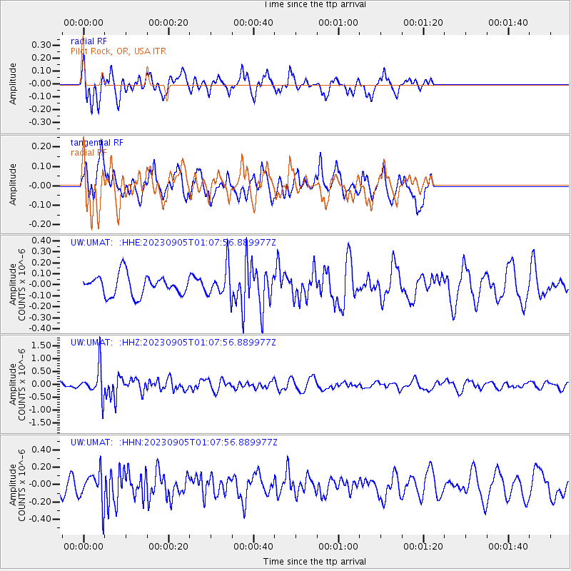
UMAT Pilot Rock, OR, USA - Earthquake Result Viewer
*The percent match for this event was below the threshold and hence no stack was calculated.
| Earthquake location: |
South Of Fiji Islands |
| Earthquake latitude/longitude: |
-23.9/175.5 |
| Earthquake time(UTC): |
2023/09/05 (248) 00:55:24 GMT |
| Earthquake Depth: |
12 km |
| Earthquake Magnitude: |
5.7 Mww |
| Earthquake Catalog/Contributor: |
NEIC PDE/us |
|
| Network: |
UW Pacific Northwest Regional Seismic Network |
| Station: |
UMAT Pilot Rock, OR, USA |
| Lat/Lon: |
45.29 N/118.96 W |
| Elevation: |
1318 m |
|
| Distance: |
91.1 deg |
| Az: |
40.001 deg |
| Baz: |
236.425 deg |
| Ray Param: |
$rayparam |
*The percent match for this event was below the threshold and hence was not used in the summary stack. |
|
| Radial Match: |
73.32014 % |
| Radial Bump: |
400 |
| Transverse Match: |
55.55405 % |
| Transverse Bump: |
400 |
| SOD ConfigId: |
31937991 |
| Insert Time: |
2023-09-19 01:22:25.968 +0000 |
| GWidth: |
2.5 |
| Max Bumps: |
400 |
| Tol: |
0.001 |
|
Signal To Noise
| Channel | StoN | STA | LTA |
| UW:UMAT: :HHZ:20230905T01:07:56.889977Z | 4.593362 | 6.004706E-7 | 1.3072574E-7 |
| UW:UMAT: :HHN:20230905T01:07:56.889977Z | 1.3305014 | 1.7877124E-7 | 1.3436382E-7 |
| UW:UMAT: :HHE:20230905T01:07:56.889977Z | 1.518963 | 1.384961E-7 | 9.1178066E-8 |
| Arrivals |
| Ps | |
| PpPs | |
| PsPs/PpSs | |


