You are here: Home > Network List > IW - Intermountain West Stations List
> Station MOOW Moose Ponds, Wyoming, USA > Earthquake Result Viewer
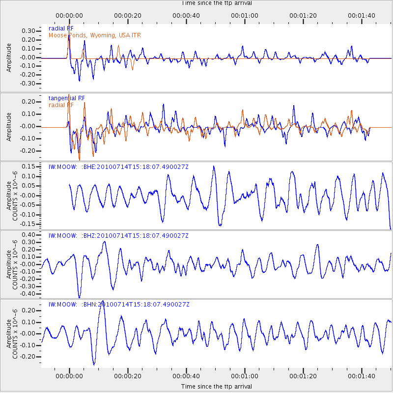
MOOW Moose Ponds, Wyoming, USA - Earthquake Result Viewer
*The percent match for this event was below the threshold and hence no stack was calculated.
| Earthquake location: |
Near Coast Of Central Chile |
| Earthquake latitude/longitude: |
-38.2/-73.2 |
| Earthquake time(UTC): |
2010/07/14 (195) 15:05:50 GMT |
| Earthquake Depth: |
35 km |
| Earthquake Magnitude: |
5.5 MS, 5.4 MB, 5.8 MW, 5.7 MW |
| Earthquake Catalog/Contributor: |
WHDF/NEIC |
|
| Network: |
IW Intermountain West |
| Station: |
MOOW Moose Ponds, Wyoming, USA |
| Lat/Lon: |
43.75 N/110.74 W |
| Elevation: |
2128 m |
|
| Distance: |
88.4 deg |
| Az: |
333.801 deg |
| Baz: |
151.326 deg |
| Ray Param: |
$rayparam |
*The percent match for this event was below the threshold and hence was not used in the summary stack. |
|
| Radial Match: |
59.748276 % |
| Radial Bump: |
400 |
| Transverse Match: |
60.18481 % |
| Transverse Bump: |
400 |
| SOD ConfigId: |
319893 |
| Insert Time: |
2011-01-05 04:11:31.103 +0000 |
| GWidth: |
2.5 |
| Max Bumps: |
400 |
| Tol: |
0.001 |
|
Signal To Noise
| Channel | StoN | STA | LTA |
| IW:MOOW: :BHZ:20100714T15:18:07.490027Z | 2.9133098 | 2.0110423E-7 | 6.902947E-8 |
| IW:MOOW: :BHN:20100714T15:18:07.490027Z | 0.8575067 | 5.989492E-8 | 6.984776E-8 |
| IW:MOOW: :BHE:20100714T15:18:07.490027Z | 1.8989735 | 7.6245335E-8 | 4.015082E-8 |
| Arrivals |
| Ps | |
| PpPs | |
| PsPs/PpSs | |


