You are here: Home > Network List > AK - Alaska Regional Network Stations List
> Station BAT Barry Arm Top, AK, USA > Earthquake Result Viewer
BAT Barry Arm Top, AK, USA - Earthquake Result Viewer
| Earthquake location: |
New Guinea, Papua New Guinea |
| Earthquake latitude/longitude: |
-5.3/142.9 |
| Earthquake time(UTC): |
2023/09/05 (248) 15:03:17 GMT |
| Earthquake Depth: |
52 km |
| Earthquake Magnitude: |
5.8 mww |
| Earthquake Catalog/Contributor: |
NEIC PDE/us |
|
| Network: |
AK Alaska Regional Network |
| Station: |
BAT Barry Arm Top, AK, USA |
| Lat/Lon: |
61.14 N/148.18 W |
| Elevation: |
1027 m |
|
| Distance: |
84.6 deg |
| Az: |
27.048 deg |
| Baz: |
248.969 deg |
| Ray Param: |
0.045246623 |
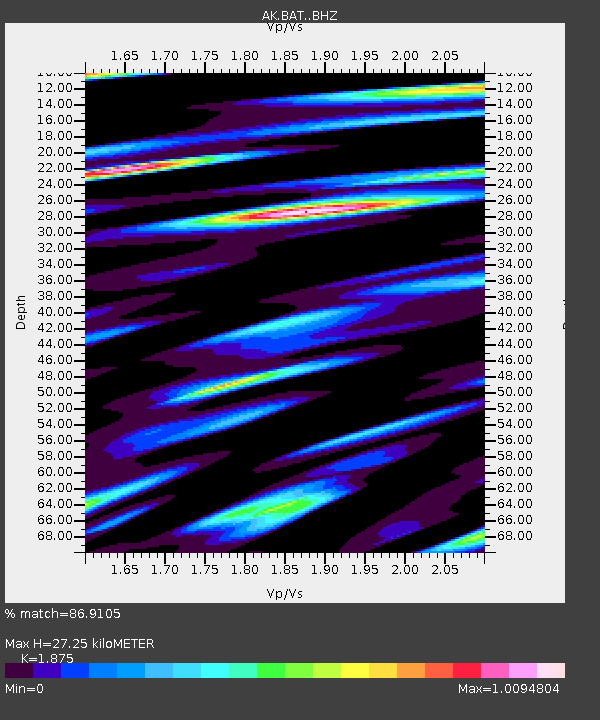
| Estimated Moho Depth: |
27.25 km |
| Estimated Crust Vp/Vs: |
1.88 |
| Assumed Crust Vp: |
6.566 km/s |
| Estimated Crust Vs: |
3.502 km/s |
| Estimated Crust Poisson's Ratio: |
0.30 |
|
| Radial Match: |
86.9105 % |
| Radial Bump: |
400 |
| Transverse Match: |
80.11054 % |
| Transverse Bump: |
400 |
| SOD ConfigId: |
31937991 |
| Insert Time: |
2023-09-19 15:05:15.698 +0000 |
| GWidth: |
2.5 |
| Max Bumps: |
400 |
| Tol: |
0.001 |
|

Signal To Noise
| Channel | StoN | STA | LTA |
| AK:BAT: :BHZ:20230905T15:15:14.120008Z | 9.48787 | 6.873092E-7 | 7.2440834E-8 |
| AK:BAT: :BHN:20230905T15:15:14.120008Z | 4.670938 | 2.2741756E-7 | 4.8687767E-8 |
| AK:BAT: :BHE:20230905T15:15:14.120008Z | 6.6173806 | 4.0424368E-7 | 6.1088166E-8 |
| Arrivals |
| Ps | 3.7 SECOND |
| PpPs | 12 SECOND |
| PsPs/PpSs | 15 SECOND |


