You are here: Home > Network List > AK - Alaska Regional Network Stations List
> Station K15K Wolf Creek Mountain, AK, USA > Earthquake Result Viewer
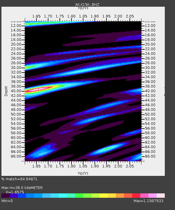
K15K Wolf Creek Mountain, AK, USA - Earthquake Result Viewer
| Earthquake location: |
New Guinea, Papua New Guinea |
| Earthquake latitude/longitude: |
-5.3/142.9 |
| Earthquake time(UTC): |
2023/09/05 (248) 15:03:17 GMT |
| Earthquake Depth: |
52 km |
| Earthquake Magnitude: |
5.8 mww |
| Earthquake Catalog/Contributor: |
NEIC PDE/us |
|
| Network: |
AK Alaska Regional Network |
| Station: |
K15K Wolf Creek Mountain, AK, USA |
| Lat/Lon: |
62.29 N/161.53 W |
| Elevation: |
346 m |
|
| Distance: |
79.5 deg |
| Az: |
23.089 deg |
| Baz: |
236.667 deg |
| Ray Param: |
0.048810773 |
| Estimated Moho Depth: |
39.0 km |
| Estimated Crust Vp/Vs: |
1.66 |
| Assumed Crust Vp: |
6.276 km/s |
| Estimated Crust Vs: |
3.786 km/s |
| Estimated Crust Poisson's Ratio: |
0.21 |
|
| Radial Match: |
84.94671 % |
| Radial Bump: |
317 |
| Transverse Match: |
63.874523 % |
| Transverse Bump: |
397 |
| SOD ConfigId: |
31937991 |
| Insert Time: |
2023-09-19 15:07:14.486 +0000 |
| GWidth: |
2.5 |
| Max Bumps: |
400 |
| Tol: |
0.001 |
|

Signal To Noise
| Channel | StoN | STA | LTA |
| AK:K15K: :BHZ:20230905T15:14:47.380018Z | 8.201198 | 1.4495845E-6 | 1.7675279E-7 |
| AK:K15K: :BHN:20230905T15:14:47.380018Z | 2.5934026 | 4.421514E-7 | 1.7049082E-7 |
| AK:K15K: :BHE:20230905T15:14:47.380018Z | 3.1400666 | 4.6257765E-7 | 1.473146E-7 |
| Arrivals |
| Ps | 4.2 SECOND |
| PpPs | 16 SECOND |
| PsPs/PpSs | 20 SECOND |


