You are here: Home > Network List > AV - Alaska Volcano Observatory Stations List
> Station R17L Mt. Peulik Volcano, AVO PLK4, AK, USA > Earthquake Result Viewer
R17L Mt. Peulik Volcano, AVO PLK4, AK, USA - Earthquake Result Viewer
| Earthquake location: |
New Guinea, Papua New Guinea |
| Earthquake latitude/longitude: |
-5.3/142.9 |
| Earthquake time(UTC): |
2023/09/05 (248) 15:03:17 GMT |
| Earthquake Depth: |
52 km |
| Earthquake Magnitude: |
5.8 mww |
| Earthquake Catalog/Contributor: |
NEIC PDE/us |
|
| Network: |
AV Alaska Volcano Observatory |
| Station: |
R17L Mt. Peulik Volcano, AVO PLK4, AK, USA |
| Lat/Lon: |
57.63 N/156.36 W |
| Elevation: |
524 m |
|
| Distance: |
79.4 deg |
| Az: |
28.528 deg |
| Baz: |
242.137 deg |
| Ray Param: |
0.048908606 |
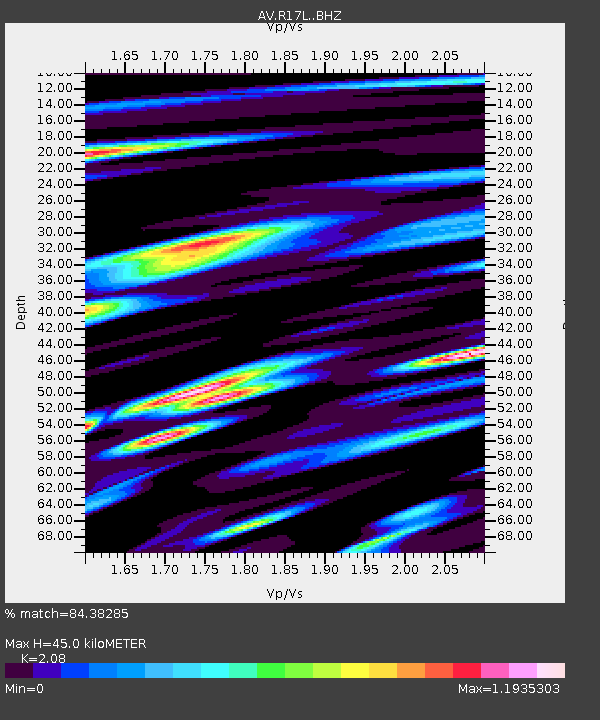
| Estimated Moho Depth: |
45.0 km |
| Estimated Crust Vp/Vs: |
2.08 |
| Assumed Crust Vp: |
6.1 km/s |
| Estimated Crust Vs: |
2.933 km/s |
| Estimated Crust Poisson's Ratio: |
0.35 |
|
| Radial Match: |
84.38285 % |
| Radial Bump: |
400 |
| Transverse Match: |
79.728966 % |
| Transverse Bump: |
400 |
| SOD ConfigId: |
31937991 |
| Insert Time: |
2023-09-19 15:12:37.174 +0000 |
| GWidth: |
2.5 |
| Max Bumps: |
400 |
| Tol: |
0.001 |
|

Signal To Noise
| Channel | StoN | STA | LTA |
| AV:R17L: :BHZ:20230905T15:14:46.625013Z | 7.300645 | 1.7404024E-6 | 2.3839023E-7 |
| AV:R17L: :BHN:20230905T15:14:46.625013Z | 1.5550867 | 2.9127605E-7 | 1.8730535E-7 |
| AV:R17L: :BHE:20230905T15:14:46.625013Z | 3.4591174 | 5.475387E-7 | 1.5828856E-7 |
| Arrivals |
| Ps | 8.1 SECOND |
| PpPs | 22 SECOND |
| PsPs/PpSs | 30 SECOND |


