You are here: Home > Network List > TA - USArray Transportable Network (new EarthScope stations) Stations List
> Station R27A Eads, CO, USA > Earthquake Result Viewer
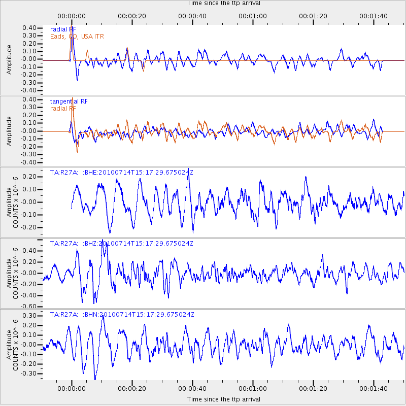
R27A Eads, CO, USA - Earthquake Result Viewer
*The percent match for this event was below the threshold and hence no stack was calculated.
| Earthquake location: |
Near Coast Of Central Chile |
| Earthquake latitude/longitude: |
-38.2/-73.2 |
| Earthquake time(UTC): |
2010/07/14 (195) 15:05:50 GMT |
| Earthquake Depth: |
35 km |
| Earthquake Magnitude: |
5.5 MS, 5.4 MB, 5.8 MW, 5.7 MW |
| Earthquake Catalog/Contributor: |
WHDF/NEIC |
|
| Network: |
TA USArray Transportable Network (new EarthScope stations) |
| Station: |
R27A Eads, CO, USA |
| Lat/Lon: |
38.29 N/102.80 W |
| Elevation: |
1201 m |
|
| Distance: |
80.9 deg |
| Az: |
336.839 deg |
| Baz: |
156.818 deg |
| Ray Param: |
$rayparam |
*The percent match for this event was below the threshold and hence was not used in the summary stack. |
|
| Radial Match: |
54.661037 % |
| Radial Bump: |
400 |
| Transverse Match: |
49.56466 % |
| Transverse Bump: |
400 |
| SOD ConfigId: |
319893 |
| Insert Time: |
2011-01-05 04:18:56.534 +0000 |
| GWidth: |
2.5 |
| Max Bumps: |
400 |
| Tol: |
0.001 |
|
Signal To Noise
| Channel | StoN | STA | LTA |
| TA:R27A: :BHZ:20100714T15:17:29.675024Z | 2.7285986 | 2.5092825E-7 | 9.196231E-8 |
| TA:R27A: :BHN:20100714T15:17:29.675024Z | 1.8708421 | 1.5735223E-7 | 8.4107704E-8 |
| TA:R27A: :BHE:20100714T15:17:29.675024Z | 0.73075753 | 7.6019184E-8 | 1.0402791E-7 |
| Arrivals |
| Ps | |
| PpPs | |
| PsPs/PpSs | |


