You are here: Home > Network List > TA - USArray Transportable Network (new EarthScope stations) Stations List
> Station T28A Walsh, CO, USA > Earthquake Result Viewer
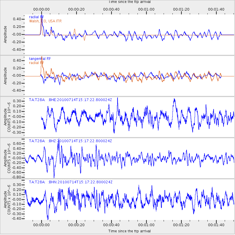
T28A Walsh, CO, USA - Earthquake Result Viewer
*The percent match for this event was below the threshold and hence no stack was calculated.
| Earthquake location: |
Near Coast Of Central Chile |
| Earthquake latitude/longitude: |
-38.2/-73.2 |
| Earthquake time(UTC): |
2010/07/14 (195) 15:05:50 GMT |
| Earthquake Depth: |
35 km |
| Earthquake Magnitude: |
5.5 MS, 5.4 MB, 5.8 MW, 5.7 MW |
| Earthquake Catalog/Contributor: |
WHDF/NEIC |
|
| Network: |
TA USArray Transportable Network (new EarthScope stations) |
| Station: |
T28A Walsh, CO, USA |
| Lat/Lon: |
37.12 N/102.11 W |
| Elevation: |
1148 m |
|
| Distance: |
79.6 deg |
| Az: |
336.885 deg |
| Baz: |
157.243 deg |
| Ray Param: |
$rayparam |
*The percent match for this event was below the threshold and hence was not used in the summary stack. |
|
| Radial Match: |
60.735386 % |
| Radial Bump: |
400 |
| Transverse Match: |
51.13602 % |
| Transverse Bump: |
400 |
| SOD ConfigId: |
319893 |
| Insert Time: |
2011-01-05 04:19:00.453 +0000 |
| GWidth: |
2.5 |
| Max Bumps: |
400 |
| Tol: |
0.001 |
|
Signal To Noise
| Channel | StoN | STA | LTA |
| TA:T28A: :BHZ:20100714T15:17:22.800024Z | 2.4805837 | 2.6487362E-7 | 1.0677876E-7 |
| TA:T28A: :BHN:20100714T15:17:22.800024Z | 1.5961603 | 1.6844194E-7 | 1.05529466E-7 |
| TA:T28A: :BHE:20100714T15:17:22.800024Z | 0.56328773 | 6.217472E-8 | 1.1037825E-7 |
| Arrivals |
| Ps | |
| PpPs | |
| PsPs/PpSs | |


