You are here: Home > Network List > TA - USArray Transportable Network (new EarthScope stations) Stations List
> Station POKR Poker Plat Research Range, AK, USA > Earthquake Result Viewer
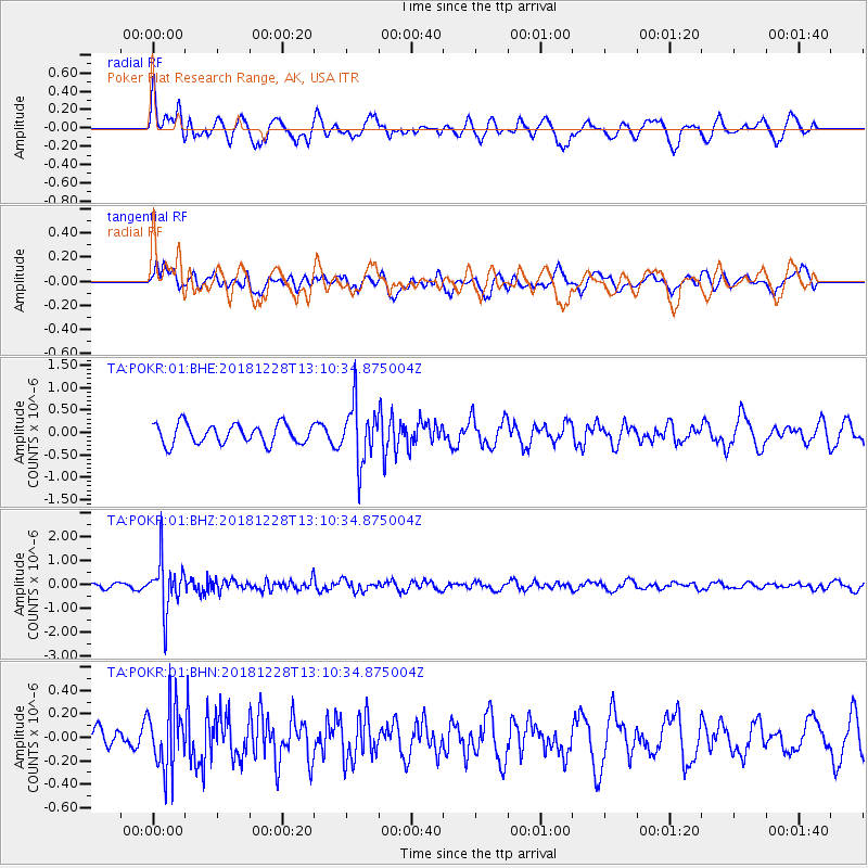
POKR Poker Plat Research Range, AK, USA - Earthquake Result Viewer
*The percent match for this event was below the threshold and hence no stack was calculated.
| Earthquake location: |
Kuril Islands |
| Earthquake latitude/longitude: |
44.2/148.6 |
| Earthquake time(UTC): |
2018/12/28 (362) 13:03:33 GMT |
| Earthquake Depth: |
49 km |
| Earthquake Magnitude: |
5.5 mb |
| Earthquake Catalog/Contributor: |
NEIC PDE/us |
|
| Network: |
TA USArray Transportable Network (new EarthScope stations) |
| Station: |
POKR Poker Plat Research Range, AK, USA |
| Lat/Lon: |
65.12 N/147.43 W |
| Elevation: |
501 m |
|
| Distance: |
40.3 deg |
| Az: |
36.029 deg |
| Baz: |
270.717 deg |
| Ray Param: |
$rayparam |
*The percent match for this event was below the threshold and hence was not used in the summary stack. |
|
| Radial Match: |
72.0361 % |
| Radial Bump: |
400 |
| Transverse Match: |
64.83178 % |
| Transverse Bump: |
400 |
| SOD ConfigId: |
3201911 |
| Insert Time: |
2019-01-11 13:09:54.628 +0000 |
| GWidth: |
2.5 |
| Max Bumps: |
400 |
| Tol: |
0.001 |
|
Signal To Noise
| Channel | StoN | STA | LTA |
| TA:POKR:01:BHZ:20181228T13:10:34.875004Z | 9.260888 | 1.0319753E-6 | 1.11433735E-7 |
| TA:POKR:01:BHN:20181228T13:10:34.875004Z | 2.1035638 | 2.7712426E-7 | 1.3174035E-7 |
| TA:POKR:01:BHE:20181228T13:10:34.875004Z | 2.8906496 | 6.37147E-7 | 2.2041655E-7 |
| Arrivals |
| Ps | |
| PpPs | |
| PsPs/PpSs | |


