You are here: Home > Network List > TM - Thai Seismic Monitoring Network Stations List
> Station PANO PANO staion > Earthquake Result Viewer
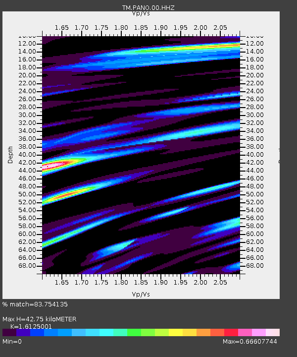
PANO PANO staion - Earthquake Result Viewer
| Earthquake location: |
New Guinea, Papua New Guinea |
| Earthquake latitude/longitude: |
-5.3/142.9 |
| Earthquake time(UTC): |
2023/09/05 (248) 15:03:17 GMT |
| Earthquake Depth: |
52 km |
| Earthquake Magnitude: |
5.8 mww |
| Earthquake Catalog/Contributor: |
NEIC PDE/us |
|
| Network: |
TM Thai Seismic Monitoring Network |
| Station: |
PANO PANO staion |
| Lat/Lon: |
17.15 N/104.61 E |
| Elevation: |
136 m |
|
| Distance: |
43.9 deg |
| Az: |
301.35 deg |
| Baz: |
117.196 deg |
| Ray Param: |
0.07212901 |
| Estimated Moho Depth: |
42.75 km |
| Estimated Crust Vp/Vs: |
1.61 |
| Assumed Crust Vp: |
6.498 km/s |
| Estimated Crust Vs: |
4.029 km/s |
| Estimated Crust Poisson's Ratio: |
0.19 |
|
| Radial Match: |
83.754135 % |
| Radial Bump: |
400 |
| Transverse Match: |
75.46382 % |
| Transverse Bump: |
400 |
| SOD ConfigId: |
31937991 |
| Insert Time: |
2023-09-19 15:21:21.204 +0000 |
| GWidth: |
2.5 |
| Max Bumps: |
400 |
| Tol: |
0.001 |
|

Signal To Noise
| Channel | StoN | STA | LTA |
| TM:PANO:00:HHZ:20230905T15:10:48.159986Z | 14.370857 | 2.1093435E-7 | 1.4677924E-8 |
| TM:PANO:00:HHN:20230905T15:10:48.159986Z | 0.9308689 | 1.711625E-8 | 1.838739E-8 |
| TM:PANO:00:HHE:20230905T15:10:48.159986Z | 4.86051 | 8.623115E-8 | 1.7741174E-8 |
| Arrivals |
| Ps | 4.3 SECOND |
| PpPs | 16 SECOND |
| PsPs/PpSs | 20 SECOND |


