You are here: Home > Network List > TA - USArray Transportable Network (new EarthScope stations) Stations List
> Station TOLK Toolik Lake Research Station, AK, USA > Earthquake Result Viewer
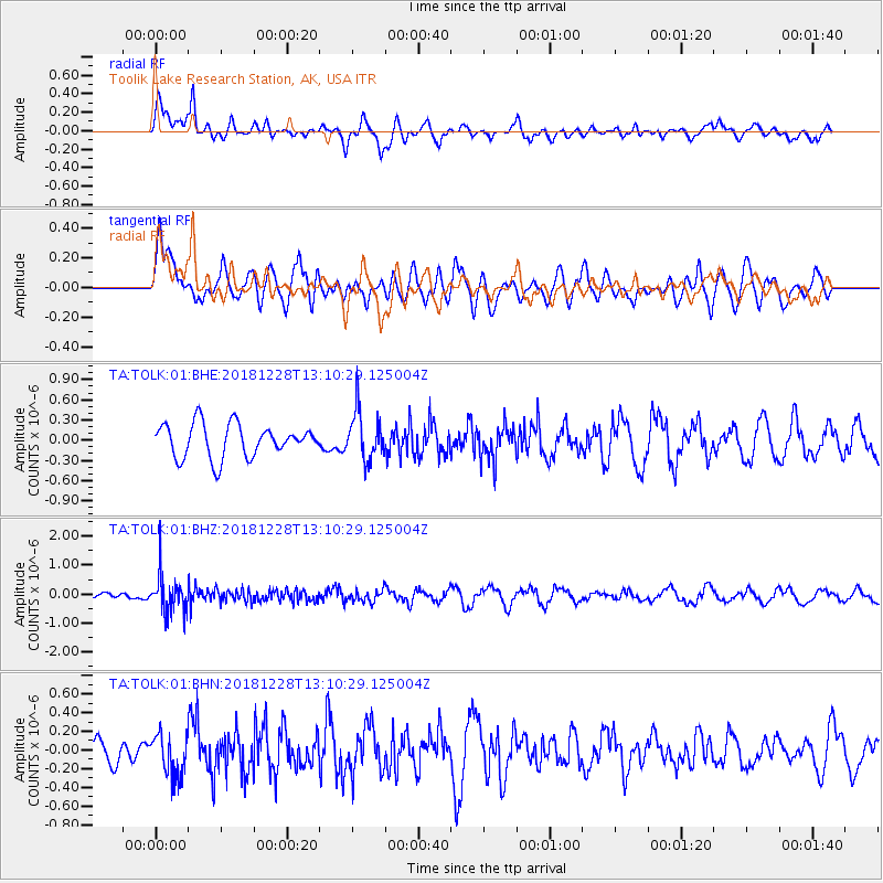
TOLK Toolik Lake Research Station, AK, USA - Earthquake Result Viewer
*The percent match for this event was below the threshold and hence no stack was calculated.
| Earthquake location: |
Kuril Islands |
| Earthquake latitude/longitude: |
44.2/148.6 |
| Earthquake time(UTC): |
2018/12/28 (362) 13:03:33 GMT |
| Earthquake Depth: |
49 km |
| Earthquake Magnitude: |
5.5 mb |
| Earthquake Catalog/Contributor: |
NEIC PDE/us |
|
| Network: |
TA USArray Transportable Network (new EarthScope stations) |
| Station: |
TOLK Toolik Lake Research Station, AK, USA |
| Lat/Lon: |
68.64 N/149.57 W |
| Elevation: |
760 m |
|
| Distance: |
39.6 deg |
| Az: |
30.463 deg |
| Baz: |
264.48 deg |
| Ray Param: |
$rayparam |
*The percent match for this event was below the threshold and hence was not used in the summary stack. |
|
| Radial Match: |
56.791695 % |
| Radial Bump: |
400 |
| Transverse Match: |
49.77518 % |
| Transverse Bump: |
400 |
| SOD ConfigId: |
3201911 |
| Insert Time: |
2019-01-11 13:09:57.756 +0000 |
| GWidth: |
2.5 |
| Max Bumps: |
400 |
| Tol: |
0.001 |
|
Signal To Noise
| Channel | StoN | STA | LTA |
| TA:TOLK:01:BHZ:20181228T13:10:29.125004Z | 6.1639185 | 6.727536E-7 | 1.0914382E-7 |
| TA:TOLK:01:BHN:20181228T13:10:29.125004Z | 1.5076514 | 2.2871497E-7 | 1.517028E-7 |
| TA:TOLK:01:BHE:20181228T13:10:29.125004Z | 1.4538829 | 3.5595252E-7 | 2.4482887E-7 |
| Arrivals |
| Ps | |
| PpPs | |
| PsPs/PpSs | |


