You are here: Home > Network List > TA - USArray Transportable Network (new EarthScope stations) Stations List
> Station Q28A Sharon Springs, KS, USA > Earthquake Result Viewer
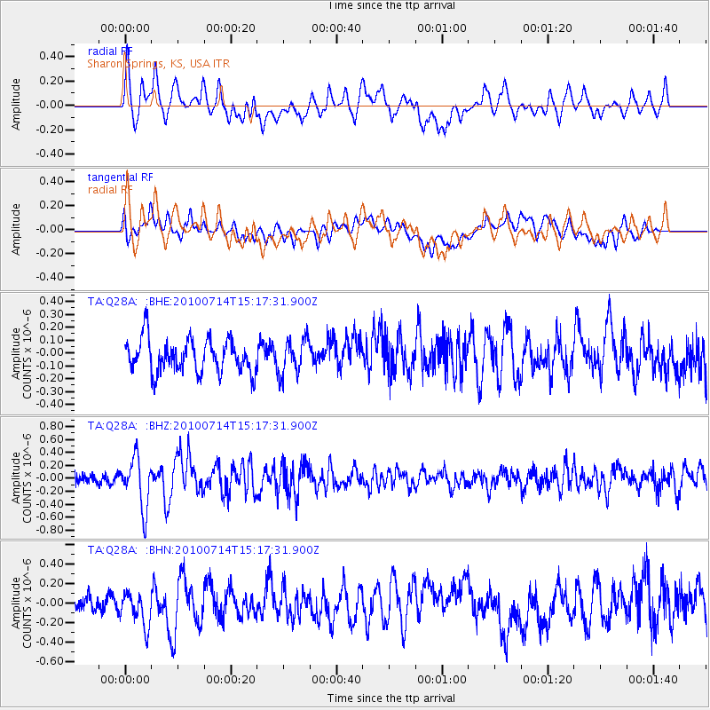
Q28A Sharon Springs, KS, USA - Earthquake Result Viewer
*The percent match for this event was below the threshold and hence no stack was calculated.
| Earthquake location: |
Near Coast Of Central Chile |
| Earthquake latitude/longitude: |
-38.2/-73.2 |
| Earthquake time(UTC): |
2010/07/14 (195) 15:05:50 GMT |
| Earthquake Depth: |
35 km |
| Earthquake Magnitude: |
5.5 MS, 5.4 MB, 5.8 MW, 5.7 MW |
| Earthquake Catalog/Contributor: |
WHDF/NEIC |
|
| Network: |
TA USArray Transportable Network (new EarthScope stations) |
| Station: |
Q28A Sharon Springs, KS, USA |
| Lat/Lon: |
39.06 N/101.83 W |
| Elevation: |
1133 m |
|
| Distance: |
81.3 deg |
| Az: |
337.849 deg |
| Baz: |
157.577 deg |
| Ray Param: |
$rayparam |
*The percent match for this event was below the threshold and hence was not used in the summary stack. |
|
| Radial Match: |
65.268074 % |
| Radial Bump: |
400 |
| Transverse Match: |
45.486942 % |
| Transverse Bump: |
400 |
| SOD ConfigId: |
319893 |
| Insert Time: |
2011-01-05 04:24:20.265 +0000 |
| GWidth: |
2.5 |
| Max Bumps: |
400 |
| Tol: |
0.001 |
|
Signal To Noise
| Channel | StoN | STA | LTA |
| TA:Q28A: :BHZ:20100714T15:17:31.900Z | 4.6416597 | 3.8857726E-7 | 8.371515E-8 |
| TA:Q28A: :BHN:20100714T15:17:31.900Z | 1.1796827 | 1.7723934E-7 | 1.5024322E-7 |
| TA:Q28A: :BHE:20100714T15:17:31.900Z | 1.0365965 | 1.3459363E-7 | 1.2984188E-7 |
| Arrivals |
| Ps | |
| PpPs | |
| PsPs/PpSs | |


