You are here: Home > Network List > II - Global Seismograph Network (GSN - IRIS/IDA) Stations List
> Station ABPO Ambohimpanompo, Madagascar > Earthquake Result Viewer
ABPO Ambohimpanompo, Madagascar - Earthquake Result Viewer

| Earthquake location: |
Mindanao, Philippines |
| Earthquake latitude/longitude: |
5.8/126.9 |
| Earthquake time(UTC): |
2018/12/29 (363) 03:39:12 GMT |
| Earthquake Depth: |
49 km |
| Earthquake Magnitude: |
7.2 Mi |
| Earthquake Catalog/Contributor: |
NEIC PDE/at |
|
| Network: |
II Global Seismograph Network (GSN - IRIS/IDA) |
| Station: |
ABPO Ambohimpanompo, Madagascar |
| Lat/Lon: |
19.02 S/47.23 E |
| Elevation: |
1528 m |
|
| Distance: |
82.2 deg |
| Az: |
249.971 deg |
| Baz: |
81.13 deg |
| Ray Param: |
0.046989918 |
| Estimated Moho Depth: |
44.0 km |
| Estimated Crust Vp/Vs: |
1.60 |
| Assumed Crust Vp: |
6.642 km/s |
| Estimated Crust Vs: |
4.151 km/s |
| Estimated Crust Poisson's Ratio: |
0.18 |
|
| Radial Match: |
95.922806 % |
| Radial Bump: |
400 |
| Transverse Match: |
88.11624 % |
| Transverse Bump: |
400 |
| SOD ConfigId: |
3201911 |
| Insert Time: |
2019-01-12 03:46:54.324 +0000 |
| GWidth: |
2.5 |
| Max Bumps: |
400 |
| Tol: |
0.001 |
|
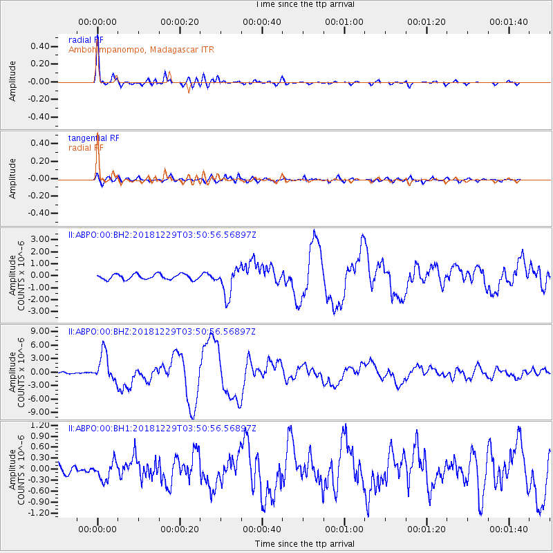
Signal To Noise
| Channel | StoN | STA | LTA |
| II:ABPO:00:BHZ:20181229T03:50:56.56897Z | 10.494686 | 3.2468824E-6 | 3.0938347E-7 |
| II:ABPO:00:BH1:20181229T03:50:56.56897Z | 1.570521 | 2.477884E-7 | 1.5777465E-7 |
| II:ABPO:00:BH2:20181229T03:50:56.56897Z | 5.4439616 | 1.2039171E-6 | 2.2114725E-7 |
| Arrivals |
| Ps | 4.1 SECOND |
| PpPs | 17 SECOND |
| PsPs/PpSs | 21 SECOND |


