You are here: Home > Network List > GM - US Geological Survey Networks Stations List
> Station NMP23 New Mexico Permian - Site# W2S3 > Earthquake Result Viewer
NMP23 New Mexico Permian - Site# W2S3 - Earthquake Result Viewer
| Earthquake location: |
Near Coast Of Central Chile |
| Earthquake latitude/longitude: |
-30.3/-71.5 |
| Earthquake time(UTC): |
2023/09/06 (249) 23:48:05 GMT |
| Earthquake Depth: |
41 km |
| Earthquake Magnitude: |
6.2 mww |
| Earthquake Catalog/Contributor: |
NEIC PDE/us |
|
| Network: |
GM US Geological Survey Networks |
| Station: |
NMP23 New Mexico Permian - Site# W2S3 |
| Lat/Lon: |
32.17 N/103.80 W |
| Elevation: |
1050 m |
|
| Distance: |
69.2 deg |
| Az: |
331.038 deg |
| Baz: |
150.402 deg |
| Ray Param: |
0.05571119 |
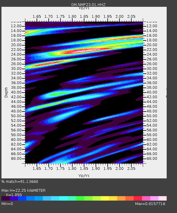
| Estimated Moho Depth: |
22.25 km |
| Estimated Crust Vp/Vs: |
1.86 |
| Assumed Crust Vp: |
6.129 km/s |
| Estimated Crust Vs: |
3.304 km/s |
| Estimated Crust Poisson's Ratio: |
0.30 |
|
| Radial Match: |
91.13668 % |
| Radial Bump: |
400 |
| Transverse Match: |
82.559586 % |
| Transverse Bump: |
400 |
| SOD ConfigId: |
31937991 |
| Insert Time: |
2023-09-21 00:00:56.736 +0000 |
| GWidth: |
2.5 |
| Max Bumps: |
400 |
| Tol: |
0.001 |
|

Signal To Noise
| Channel | StoN | STA | LTA |
| GM:NMP23:01:HHZ:20230906T23:58:36.814977Z | 14.532324 | 2.0070577E-6 | 1.3810988E-7 |
| GM:NMP23:01:HHN:20230906T23:58:36.814977Z | 4.480535 | 4.9844675E-7 | 1.11247154E-7 |
| GM:NMP23:01:HHE:20230906T23:58:36.814977Z | 4.6869226 | 4.4506723E-7 | 9.4959375E-8 |
| Arrivals |
| Ps | 3.2 SECOND |
| PpPs | 10 SECOND |
| PsPs/PpSs | 13 SECOND |


