You are here: Home > Network List > GM - US Geological Survey Networks Stations List
> Station NMP35 New Mexico Permian - Site# W3S5 > Earthquake Result Viewer
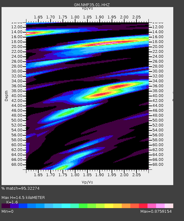
NMP35 New Mexico Permian - Site# W3S5 - Earthquake Result Viewer
| Earthquake location: |
Near Coast Of Central Chile |
| Earthquake latitude/longitude: |
-30.3/-71.5 |
| Earthquake time(UTC): |
2023/09/06 (249) 23:48:05 GMT |
| Earthquake Depth: |
41 km |
| Earthquake Magnitude: |
6.2 mww |
| Earthquake Catalog/Contributor: |
NEIC PDE/us |
|
| Network: |
GM US Geological Survey Networks |
| Station: |
NMP35 New Mexico Permian - Site# W3S5 |
| Lat/Lon: |
32.35 N/103.72 W |
| Elevation: |
1071 m |
|
| Distance: |
69.4 deg |
| Az: |
331.197 deg |
| Baz: |
150.5 deg |
| Ray Param: |
0.055625405 |
| Estimated Moho Depth: |
14.5 km |
| Estimated Crust Vp/Vs: |
1.60 |
| Assumed Crust Vp: |
6.129 km/s |
| Estimated Crust Vs: |
3.831 km/s |
| Estimated Crust Poisson's Ratio: |
0.18 |
|
| Radial Match: |
95.32274 % |
| Radial Bump: |
400 |
| Transverse Match: |
89.57768 % |
| Transverse Bump: |
400 |
| SOD ConfigId: |
31937991 |
| Insert Time: |
2023-09-21 00:01:03.797 +0000 |
| GWidth: |
2.5 |
| Max Bumps: |
400 |
| Tol: |
0.001 |
|

Signal To Noise
| Channel | StoN | STA | LTA |
| GM:NMP35:01:HHZ:20230906T23:58:37.605016Z | 28.544579 | 2.0871041E-6 | 7.311735E-8 |
| GM:NMP35:01:HHN:20230906T23:58:37.605016Z | 5.239574 | 5.565264E-7 | 1.0621597E-7 |
| GM:NMP35:01:HHE:20230906T23:58:37.605016Z | 4.3003607 | 3.4532482E-7 | 8.030136E-8 |
| Arrivals |
| Ps | 1.5 SECOND |
| PpPs | 5.9 SECOND |
| PsPs/PpSs | 7.4 SECOND |


