You are here: Home > Network List > GM - US Geological Survey Networks Stations List
> Station NMP34 New Mexico Permian - Site# W3S4 > Earthquake Result Viewer
NMP34 New Mexico Permian - Site# W3S4 - Earthquake Result Viewer
| Earthquake location: |
Near Coast Of Central Chile |
| Earthquake latitude/longitude: |
-30.3/-71.5 |
| Earthquake time(UTC): |
2023/09/06 (249) 23:48:05 GMT |
| Earthquake Depth: |
41 km |
| Earthquake Magnitude: |
6.2 mww |
| Earthquake Catalog/Contributor: |
NEIC PDE/us |
|
| Network: |
GM US Geological Survey Networks |
| Station: |
NMP34 New Mexico Permian - Site# W3S4 |
| Lat/Lon: |
32.26 N/103.69 W |
| Elevation: |
1122 m |
|
| Distance: |
69.3 deg |
| Az: |
331.178 deg |
| Baz: |
150.512 deg |
| Ray Param: |
0.055686798 |
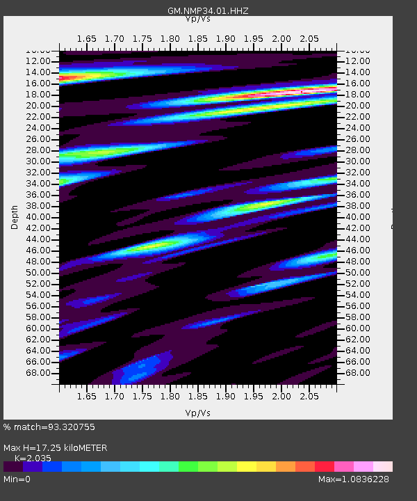
| Estimated Moho Depth: |
17.25 km |
| Estimated Crust Vp/Vs: |
2.04 |
| Assumed Crust Vp: |
6.129 km/s |
| Estimated Crust Vs: |
3.012 km/s |
| Estimated Crust Poisson's Ratio: |
0.34 |
|
| Radial Match: |
93.320755 % |
| Radial Bump: |
400 |
| Transverse Match: |
82.22072 % |
| Transverse Bump: |
400 |
| SOD ConfigId: |
31937991 |
| Insert Time: |
2023-09-21 00:01:04.206 +0000 |
| GWidth: |
2.5 |
| Max Bumps: |
400 |
| Tol: |
0.001 |
|

Signal To Noise
| Channel | StoN | STA | LTA |
| GM:NMP34:01:HHZ:20230906T23:58:37.040013Z | 9.210804 | 1.9853862E-6 | 2.155497E-7 |
| GM:NMP34:01:HHN:20230906T23:58:37.040013Z | 2.0101714 | 5.478825E-7 | 2.7255513E-7 |
| GM:NMP34:01:HHE:20230906T23:58:37.040013Z | 1.4883803 | 3.5398293E-7 | 2.3783096E-7 |
| Arrivals |
| Ps | 3.0 SECOND |
| PpPs | 8.3 SECOND |
| PsPs/PpSs | 11 SECOND |


