You are here: Home > Network List > IW - Intermountain West Stations List
> Station MOOW Moose Ponds, Wyoming, USA > Earthquake Result Viewer
MOOW Moose Ponds, Wyoming, USA - Earthquake Result Viewer
| Earthquake location: |
Near Coast Of Central Chile |
| Earthquake latitude/longitude: |
-30.3/-71.5 |
| Earthquake time(UTC): |
2023/09/06 (249) 23:48:05 GMT |
| Earthquake Depth: |
41 km |
| Earthquake Magnitude: |
6.2 mww |
| Earthquake Catalog/Contributor: |
NEIC PDE/us |
|
| Network: |
IW Intermountain West |
| Station: |
MOOW Moose Ponds, Wyoming, USA |
| Lat/Lon: |
43.75 N/110.74 W |
| Elevation: |
2128 m |
|
| Distance: |
81.9 deg |
| Az: |
332.44 deg |
| Baz: |
146.476 deg |
| Ray Param: |
0.047163635 |
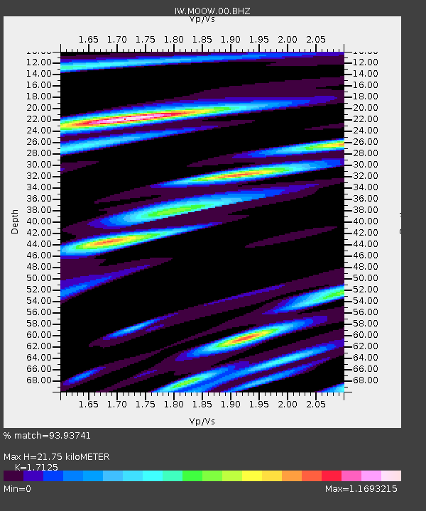
| Estimated Moho Depth: |
21.75 km |
| Estimated Crust Vp/Vs: |
1.71 |
| Assumed Crust Vp: |
6.207 km/s |
| Estimated Crust Vs: |
3.624 km/s |
| Estimated Crust Poisson's Ratio: |
0.24 |
|
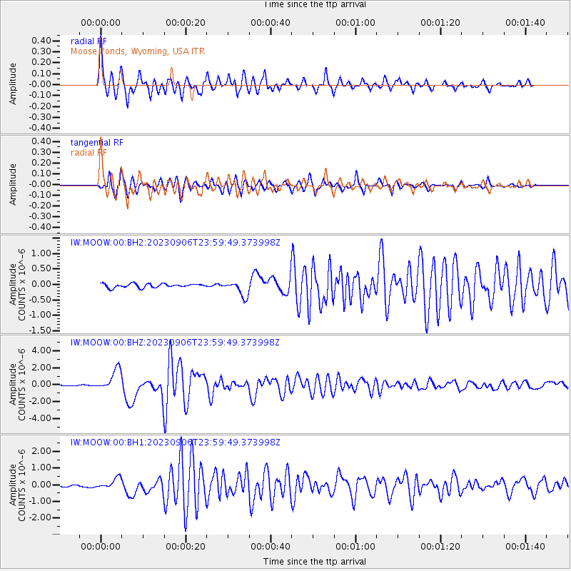
| Radial Match: |
93.93741 % |
| Radial Bump: |
400 |
| Transverse Match: |
91.139725 % |
| Transverse Bump: |
387 |
| SOD ConfigId: |
31937991 |
| Insert Time: |
2023-09-21 00:02:40.558 +0000 |
| GWidth: |
2.5 |
| Max Bumps: |
400 |
| Tol: |
0.001 |
|
Signal To Noise
| Channel | StoN | STA | LTA |
| IW:MOOW:00:BHZ:20230906T23:59:49.373998Z | 28.181965 | 1.3190366E-6 | 4.6804285E-8 |
| IW:MOOW:00:BH1:20230906T23:59:49.373998Z | 6.115981 | 3.4040013E-7 | 5.5657488E-8 |
| IW:MOOW:00:BH2:20230906T23:59:49.373998Z | 4.0516443 | 2.547369E-7 | 6.287248E-8 |
| Arrivals |
| Ps | 2.6 SECOND |
| PpPs | 9.3 SECOND |
| PsPs/PpSs | 12 SECOND |


