You are here: Home > Network List > N4 - Central and EAstern US Network Stations List
> Station E46A Sault Ste Marie, MI, USA > Earthquake Result Viewer
E46A Sault Ste Marie, MI, USA - Earthquake Result Viewer
| Earthquake location: |
Near Coast Of Central Chile |
| Earthquake latitude/longitude: |
-30.3/-71.5 |
| Earthquake time(UTC): |
2023/09/06 (249) 23:48:05 GMT |
| Earthquake Depth: |
41 km |
| Earthquake Magnitude: |
6.2 mww |
| Earthquake Catalog/Contributor: |
NEIC PDE/us |
|
| Network: |
N4 Central and EAstern US Network |
| Station: |
E46A Sault Ste Marie, MI, USA |
| Lat/Lon: |
46.37 N/84.31 W |
| Elevation: |
269 m |
|
| Distance: |
77.2 deg |
| Az: |
350.968 deg |
| Baz: |
168.69 deg |
| Ray Param: |
0.050446015 |
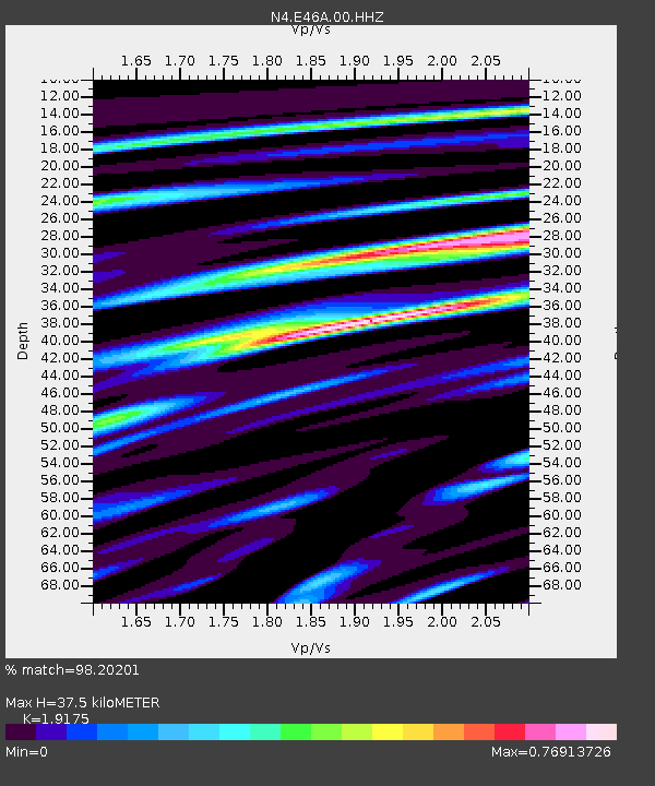
| Estimated Moho Depth: |
37.5 km |
| Estimated Crust Vp/Vs: |
1.92 |
| Assumed Crust Vp: |
6.467 km/s |
| Estimated Crust Vs: |
3.372 km/s |
| Estimated Crust Poisson's Ratio: |
0.31 |
|
| Radial Match: |
98.20201 % |
| Radial Bump: |
308 |
| Transverse Match: |
89.22621 % |
| Transverse Bump: |
400 |
| SOD ConfigId: |
31937991 |
| Insert Time: |
2023-09-21 00:04:54.531 +0000 |
| GWidth: |
2.5 |
| Max Bumps: |
400 |
| Tol: |
0.001 |
|

Signal To Noise
| Channel | StoN | STA | LTA |
| N4:E46A:00:HHZ:20230906T23:59:23.42899Z | 14.314927 | 2.4007559E-6 | 1.6770996E-7 |
| N4:E46A:00:HH1:20230906T23:59:23.42899Z | 9.160784 | 1.0221062E-6 | 1.11574096E-7 |
| N4:E46A:00:HH2:20230906T23:59:23.42899Z | 2.4566624 | 3.310986E-7 | 1.3477579E-7 |
| Arrivals |
| Ps | 5.5 SECOND |
| PpPs | 16 SECOND |
| PsPs/PpSs | 22 SECOND |


