You are here: Home > Network List > N4 - Central and EAstern US Network Stations List
> Station E62A Clayton Lake, ME, USA > Earthquake Result Viewer
E62A Clayton Lake, ME, USA - Earthquake Result Viewer
| Earthquake location: |
Near Coast Of Central Chile |
| Earthquake latitude/longitude: |
-30.3/-71.5 |
| Earthquake time(UTC): |
2023/09/06 (249) 23:48:05 GMT |
| Earthquake Depth: |
41 km |
| Earthquake Magnitude: |
6.2 mww |
| Earthquake Catalog/Contributor: |
NEIC PDE/us |
|
| Network: |
N4 Central and EAstern US Network |
| Station: |
E62A Clayton Lake, ME, USA |
| Lat/Lon: |
46.62 N/69.52 W |
| Elevation: |
356 m |
|
| Distance: |
76.6 deg |
| Az: |
1.427 deg |
| Baz: |
181.791 deg |
| Ray Param: |
0.050850842 |
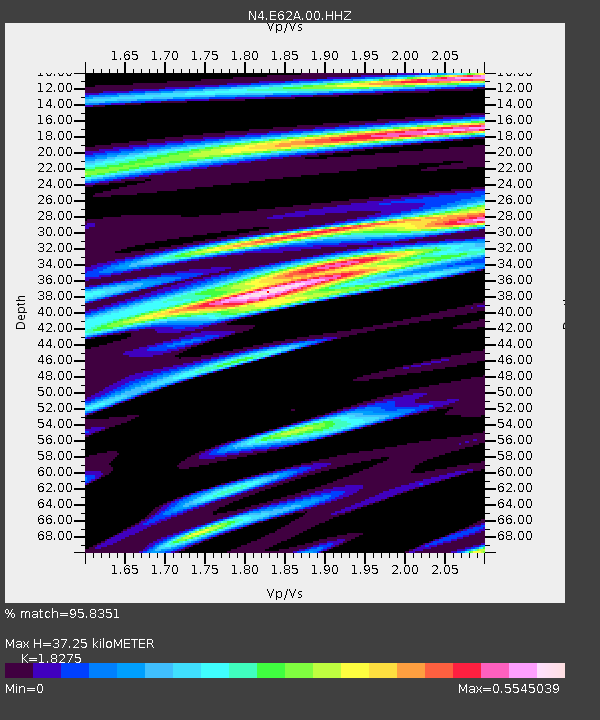
| Estimated Moho Depth: |
37.25 km |
| Estimated Crust Vp/Vs: |
1.83 |
| Assumed Crust Vp: |
6.419 km/s |
| Estimated Crust Vs: |
3.513 km/s |
| Estimated Crust Poisson's Ratio: |
0.29 |
|
| Radial Match: |
95.8351 % |
| Radial Bump: |
400 |
| Transverse Match: |
93.39296 % |
| Transverse Bump: |
340 |
| SOD ConfigId: |
31937991 |
| Insert Time: |
2023-09-21 00:04:55.808 +0000 |
| GWidth: |
2.5 |
| Max Bumps: |
400 |
| Tol: |
0.001 |
|

Signal To Noise
| Channel | StoN | STA | LTA |
| N4:E62A:00:HHZ:20230906T23:59:20.079015Z | 13.013817 | 2.1307453E-6 | 1.6372947E-7 |
| N4:E62A:00:HH1:20230906T23:59:20.079015Z | 5.4036527 | 7.060323E-7 | 1.3065835E-7 |
| N4:E62A:00:HH2:20230906T23:59:20.079015Z | 2.2501824 | 2.538826E-7 | 1.12827564E-7 |
| Arrivals |
| Ps | 4.9 SECOND |
| PpPs | 16 SECOND |
| PsPs/PpSs | 21 SECOND |


