You are here: Home > Network List > N4 - Central and EAstern US Network Stations List
> Station G65A Princeton, ME, USA > Earthquake Result Viewer
G65A Princeton, ME, USA - Earthquake Result Viewer
| Earthquake location: |
Near Coast Of Central Chile |
| Earthquake latitude/longitude: |
-30.3/-71.5 |
| Earthquake time(UTC): |
2023/09/06 (249) 23:48:05 GMT |
| Earthquake Depth: |
41 km |
| Earthquake Magnitude: |
6.2 mww |
| Earthquake Catalog/Contributor: |
NEIC PDE/us |
|
| Network: |
N4 Central and EAstern US Network |
| Station: |
G65A Princeton, ME, USA |
| Lat/Lon: |
45.20 N/67.56 W |
| Elevation: |
78 m |
|
| Distance: |
75.2 deg |
| Az: |
2.904 deg |
| Baz: |
183.554 deg |
| Ray Param: |
0.05175928 |
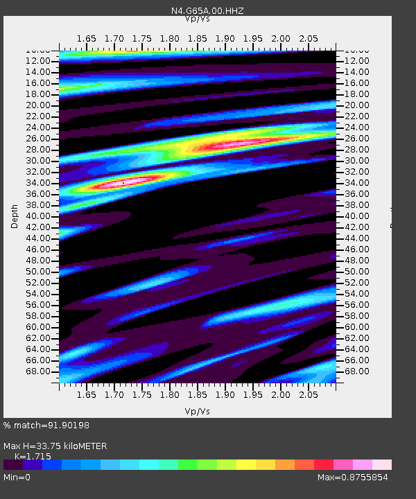
| Estimated Moho Depth: |
33.75 km |
| Estimated Crust Vp/Vs: |
1.72 |
| Assumed Crust Vp: |
6.419 km/s |
| Estimated Crust Vs: |
3.743 km/s |
| Estimated Crust Poisson's Ratio: |
0.24 |
|
| Radial Match: |
91.90198 % |
| Radial Bump: |
325 |
| Transverse Match: |
77.15576 % |
| Transverse Bump: |
400 |
| SOD ConfigId: |
31937991 |
| Insert Time: |
2023-09-21 00:05:06.691 +0000 |
| GWidth: |
2.5 |
| Max Bumps: |
400 |
| Tol: |
0.001 |
|

Signal To Noise
| Channel | StoN | STA | LTA |
| N4:G65A:00:HHZ:20230906T23:59:12.379979Z | 10.097787 | 1.8875152E-6 | 1.8692366E-7 |
| N4:G65A:00:HH1:20230906T23:59:12.379979Z | 4.3882265 | 7.5573985E-7 | 1.7221987E-7 |
| N4:G65A:00:HH2:20230906T23:59:12.379979Z | 1.3691889 | 1.9173571E-7 | 1.4003598E-7 |
| Arrivals |
| Ps | 3.9 SECOND |
| PpPs | 14 SECOND |
| PsPs/PpSs | 18 SECOND |


