You are here: Home > Network List > N4 - Central and EAstern US Network Stations List
> Station L59A Walton, NY, USA > Earthquake Result Viewer
L59A Walton, NY, USA - Earthquake Result Viewer
| Earthquake location: |
Near Coast Of Central Chile |
| Earthquake latitude/longitude: |
-30.3/-71.5 |
| Earthquake time(UTC): |
2023/09/06 (249) 23:48:05 GMT |
| Earthquake Depth: |
41 km |
| Earthquake Magnitude: |
6.2 mww |
| Earthquake Catalog/Contributor: |
NEIC PDE/us |
|
| Network: |
N4 Central and EAstern US Network |
| Station: |
L59A Walton, NY, USA |
| Lat/Lon: |
42.19 N/75.04 W |
| Elevation: |
677 m |
|
| Distance: |
72.2 deg |
| Az: |
357.263 deg |
| Baz: |
176.814 deg |
| Ray Param: |
0.053762753 |
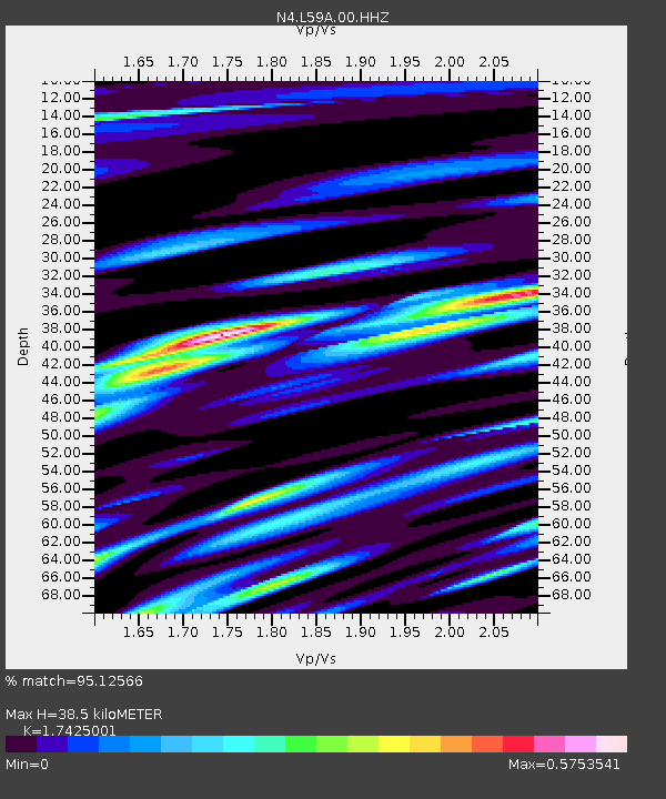
| Estimated Moho Depth: |
38.5 km |
| Estimated Crust Vp/Vs: |
1.74 |
| Assumed Crust Vp: |
6.419 km/s |
| Estimated Crust Vs: |
3.684 km/s |
| Estimated Crust Poisson's Ratio: |
0.25 |
|
| Radial Match: |
95.12566 % |
| Radial Bump: |
339 |
| Transverse Match: |
85.75463 % |
| Transverse Bump: |
400 |
| SOD ConfigId: |
31937991 |
| Insert Time: |
2023-09-21 00:05:49.158 +0000 |
| GWidth: |
2.5 |
| Max Bumps: |
400 |
| Tol: |
0.001 |
|

Signal To Noise
| Channel | StoN | STA | LTA |
| N4:L59A:00:HHZ:20230906T23:58:54.699986Z | 16.001335 | 2.2773759E-6 | 1.423241E-7 |
| N4:L59A:00:HH1:20230906T23:58:54.699986Z | 6.842738 | 1.0134444E-6 | 1.4810509E-7 |
| N4:L59A:00:HH2:20230906T23:58:54.699986Z | 1.1268737 | 1.4721405E-7 | 1.3063934E-7 |
| Arrivals |
| Ps | 4.6 SECOND |
| PpPs | 16 SECOND |
| PsPs/PpSs | 20 SECOND |


