You are here: Home > Network List > N4 - Central and EAstern US Network Stations List
> Station V53A Sandy Mush, NC, USA > Earthquake Result Viewer
V53A Sandy Mush, NC, USA - Earthquake Result Viewer
| Earthquake location: |
Near Coast Of Central Chile |
| Earthquake latitude/longitude: |
-30.3/-71.5 |
| Earthquake time(UTC): |
2023/09/06 (249) 23:48:05 GMT |
| Earthquake Depth: |
41 km |
| Earthquake Magnitude: |
6.2 mww |
| Earthquake Catalog/Contributor: |
NEIC PDE/us |
|
| Network: |
N4 Central and EAstern US Network |
| Station: |
V53A Sandy Mush, NC, USA |
| Lat/Lon: |
35.67 N/82.81 W |
| Elevation: |
681 m |
|
| Distance: |
66.5 deg |
| Az: |
349.998 deg |
| Baz: |
169.367 deg |
| Ray Param: |
0.057534084 |
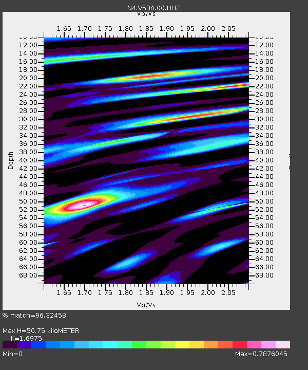
| Estimated Moho Depth: |
50.75 km |
| Estimated Crust Vp/Vs: |
1.70 |
| Assumed Crust Vp: |
6.35 km/s |
| Estimated Crust Vs: |
3.741 km/s |
| Estimated Crust Poisson's Ratio: |
0.23 |
|
| Radial Match: |
96.32458 % |
| Radial Bump: |
400 |
| Transverse Match: |
91.71501 % |
| Transverse Bump: |
400 |
| SOD ConfigId: |
31937991 |
| Insert Time: |
2023-09-21 00:07:26.518 +0000 |
| GWidth: |
2.5 |
| Max Bumps: |
400 |
| Tol: |
0.001 |
|

Signal To Noise
| Channel | StoN | STA | LTA |
| N4:V53A:00:HHZ:20230906T23:58:19.358983Z | 28.816593 | 1.8704525E-6 | 6.490887E-8 |
| N4:V53A:00:HH1:20230906T23:58:19.358983Z | 15.501461 | 7.701468E-7 | 4.9682207E-8 |
| N4:V53A:00:HH2:20230906T23:58:19.358983Z | 3.5253308 | 2.0043103E-7 | 5.6854528E-8 |
| Arrivals |
| Ps | 5.8 SECOND |
| PpPs | 21 SECOND |
| PsPs/PpSs | 26 SECOND |


