You are here: Home > Network List > ND - New CaleDonia Broadband Seismic Network Stations List
> Station KOUNC Koumac, New Caledonia > Earthquake Result Viewer
KOUNC Koumac, New Caledonia - Earthquake Result Viewer
| Earthquake location: |
Mindanao, Philippines |
| Earthquake latitude/longitude: |
5.8/126.9 |
| Earthquake time(UTC): |
2018/12/29 (363) 03:39:12 GMT |
| Earthquake Depth: |
49 km |
| Earthquake Magnitude: |
7.2 Mi |
| Earthquake Catalog/Contributor: |
NEIC PDE/at |
|
| Network: |
ND New CaleDonia Broadband Seismic Network |
| Station: |
KOUNC Koumac, New Caledonia |
| Lat/Lon: |
20.55 S/164.29 E |
| Elevation: |
88 m |
|
| Distance: |
45.1 deg |
| Az: |
126.559 deg |
| Baz: |
301.483 deg |
| Ray Param: |
0.07136487 |
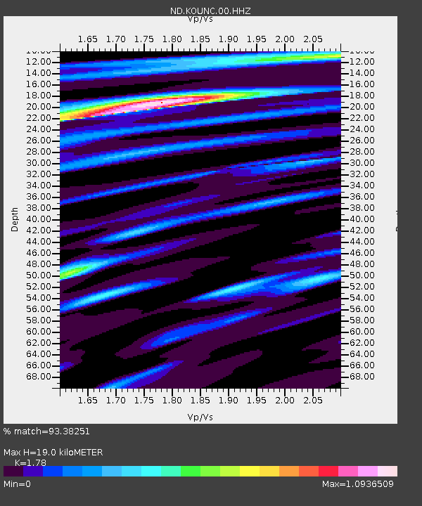
| Estimated Moho Depth: |
19.0 km |
| Estimated Crust Vp/Vs: |
1.78 |
| Assumed Crust Vp: |
5.14 km/s |
| Estimated Crust Vs: |
2.888 km/s |
| Estimated Crust Poisson's Ratio: |
0.27 |
|
| Radial Match: |
93.38251 % |
| Radial Bump: |
335 |
| Transverse Match: |
78.829765 % |
| Transverse Bump: |
400 |
| SOD ConfigId: |
3201911 |
| Insert Time: |
2019-01-12 03:47:49.435 +0000 |
| GWidth: |
2.5 |
| Max Bumps: |
400 |
| Tol: |
0.001 |
|

Signal To Noise
| Channel | StoN | STA | LTA |
| ND:KOUNC:00:HHZ:20181229T03:46:52.920013Z | 9.277517 | 1.4595992E-8 | 1.5732647E-9 |
| ND:KOUNC:00:HHN:20181229T03:46:52.920013Z | 2.2794766 | 2.9532423E-9 | 1.2955791E-9 |
| ND:KOUNC:00:HHE:20181229T03:46:52.920013Z | 3.1010952 | 6.308118E-9 | 2.034158E-9 |
| Arrivals |
| Ps | 3.0 SECOND |
| PpPs | 9.9 SECOND |
| PsPs/PpSs | 13 SECOND |


