You are here: Home > Network List > PF - Volcanologic Network of Piton de Fournaise-OVPF Stations List
> Station CIL Cilaos (Pompiers) > Earthquake Result Viewer
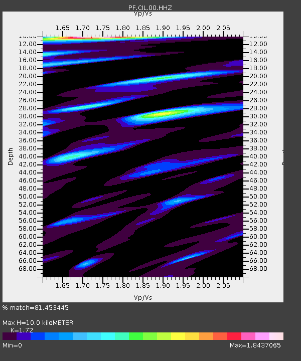
CIL Cilaos (Pompiers) - Earthquake Result Viewer
| Earthquake location: |
Mindanao, Philippines |
| Earthquake latitude/longitude: |
5.8/126.9 |
| Earthquake time(UTC): |
2018/12/29 (363) 03:39:12 GMT |
| Earthquake Depth: |
49 km |
| Earthquake Magnitude: |
7.2 Mi |
| Earthquake Catalog/Contributor: |
NEIC PDE/at |
|
| Network: |
PF Volcanologic Network of Piton de Fournaise-OVPF |
| Station: |
CIL Cilaos (Pompiers) |
| Lat/Lon: |
21.13 S/55.47 E |
| Elevation: |
1223 m |
|
| Distance: |
74.9 deg |
| Az: |
246.408 deg |
| Baz: |
77.604 deg |
| Ray Param: |
0.051907014 |
| Estimated Moho Depth: |
10.0 km |
| Estimated Crust Vp/Vs: |
1.72 |
| Assumed Crust Vp: |
4.73 km/s |
| Estimated Crust Vs: |
2.75 km/s |
| Estimated Crust Poisson's Ratio: |
0.24 |
|
| Radial Match: |
81.453445 % |
| Radial Bump: |
400 |
| Transverse Match: |
64.03601 % |
| Transverse Bump: |
400 |
| SOD ConfigId: |
3201911 |
| Insert Time: |
2019-01-12 03:48:07.314 +0000 |
| GWidth: |
2.5 |
| Max Bumps: |
400 |
| Tol: |
0.001 |
|

Signal To Noise
| Channel | StoN | STA | LTA |
| PF:CIL:00:HHZ:20181229T03:50:16.937988Z | 3.6843035 | 2.8896434E-6 | 7.84312E-7 |
| PF:CIL:00:HHN:20181229T03:50:16.937988Z | 2.0538578 | 1.1728339E-6 | 5.710395E-7 |
| PF:CIL:00:HHE:20181229T03:50:16.937988Z | 4.989823 | 2.2300183E-6 | 4.4691333E-7 |
| Arrivals |
| Ps | 1.5 SECOND |
| PpPs | 5.6 SECOND |
| PsPs/PpSs | 7.2 SECOND |


