You are here: Home > Network List > TA - USArray Transportable Network (new EarthScope stations) Stations List
> Station X37A Clayton, OK, USA > Earthquake Result Viewer
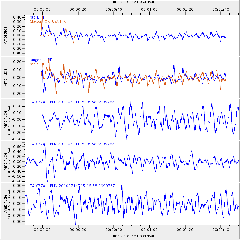
X37A Clayton, OK, USA - Earthquake Result Viewer
*The percent match for this event was below the threshold and hence no stack was calculated.
| Earthquake location: |
Near Coast Of Central Chile |
| Earthquake latitude/longitude: |
-38.2/-73.2 |
| Earthquake time(UTC): |
2010/07/14 (195) 15:05:50 GMT |
| Earthquake Depth: |
35 km |
| Earthquake Magnitude: |
5.5 MS, 5.4 MB, 5.8 MW, 5.7 MW |
| Earthquake Catalog/Contributor: |
WHDF/NEIC |
|
| Network: |
TA USArray Transportable Network (new EarthScope stations) |
| Station: |
X37A Clayton, OK, USA |
| Lat/Lon: |
34.59 N/95.37 W |
| Elevation: |
207 m |
|
| Distance: |
75.3 deg |
| Az: |
341.249 deg |
| Baz: |
162.129 deg |
| Ray Param: |
$rayparam |
*The percent match for this event was below the threshold and hence was not used in the summary stack. |
|
| Radial Match: |
52.348087 % |
| Radial Bump: |
380 |
| Transverse Match: |
53.700615 % |
| Transverse Bump: |
389 |
| SOD ConfigId: |
319893 |
| Insert Time: |
2011-01-05 04:36:22.740 +0000 |
| GWidth: |
2.5 |
| Max Bumps: |
400 |
| Tol: |
0.001 |
|
Signal To Noise
| Channel | StoN | STA | LTA |
| TA:X37A: :BHZ:20100714T15:16:58.999976Z | 3.715373 | 4.058664E-7 | 1.09239735E-7 |
| TA:X37A: :BHN:20100714T15:16:58.999976Z | 1.224603 | 1.2958859E-7 | 1.0582088E-7 |
| TA:X37A: :BHE:20100714T15:16:58.999976Z | 1.5003146 | 1.10636435E-7 | 7.374216E-8 |
| Arrivals |
| Ps | |
| PpPs | |
| PsPs/PpSs | |


