You are here: Home > Network List > PF - Volcanologic Network of Piton de Fournaise-OVPF Stations List
> Station GPS Grandes Pentes Sud > Earthquake Result Viewer
GPS Grandes Pentes Sud - Earthquake Result Viewer
| Earthquake location: |
Mindanao, Philippines |
| Earthquake latitude/longitude: |
5.8/126.9 |
| Earthquake time(UTC): |
2018/12/29 (363) 03:39:12 GMT |
| Earthquake Depth: |
49 km |
| Earthquake Magnitude: |
7.2 Mi |
| Earthquake Catalog/Contributor: |
NEIC PDE/at |
|
| Network: |
PF Volcanologic Network of Piton de Fournaise-OVPF |
| Station: |
GPS Grandes Pentes Sud |
| Lat/Lon: |
21.27 S/55.76 E |
| Elevation: |
1004 m |
|
| Distance: |
74.7 deg |
| Az: |
246.212 deg |
| Baz: |
77.448 deg |
| Ray Param: |
0.052063014 |
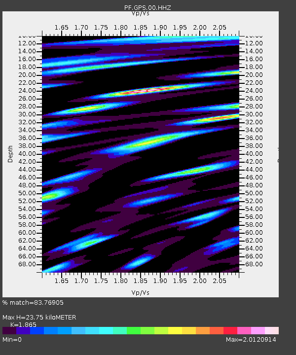
| Estimated Moho Depth: |
23.75 km |
| Estimated Crust Vp/Vs: |
1.87 |
| Assumed Crust Vp: |
4.73 km/s |
| Estimated Crust Vs: |
2.536 km/s |
| Estimated Crust Poisson's Ratio: |
0.30 |
|
| Radial Match: |
83.76905 % |
| Radial Bump: |
400 |
| Transverse Match: |
75.9777 % |
| Transverse Bump: |
400 |
| SOD ConfigId: |
3201911 |
| Insert Time: |
2019-01-12 03:48:21.063 +0000 |
| GWidth: |
2.5 |
| Max Bumps: |
400 |
| Tol: |
0.001 |
|
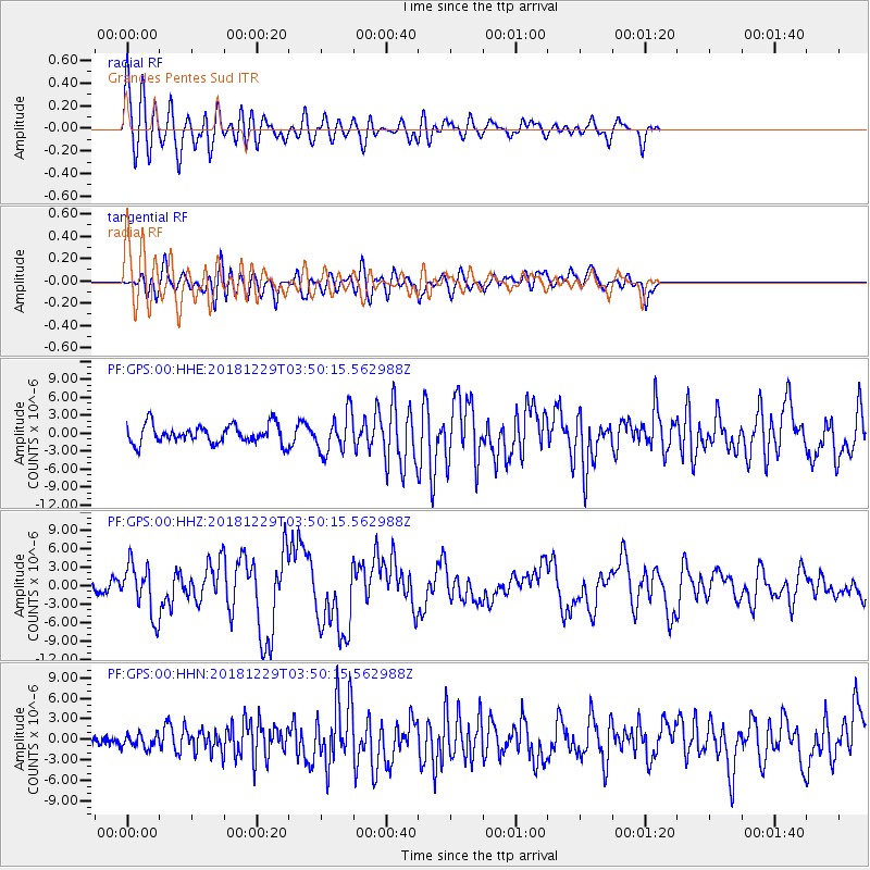
Signal To Noise
| Channel | StoN | STA | LTA |
| PF:GPS:00:HHZ:20181229T03:50:15.562988Z | 3.9668152 | 4.061108E-6 | 1.0237704E-6 |
| PF:GPS:00:HHN:20181229T03:50:15.562988Z | 0.82254857 | 9.785165E-7 | 1.1896154E-6 |
| PF:GPS:00:HHE:20181229T03:50:15.562988Z | 2.099001 | 3.2564549E-6 | 1.5514308E-6 |
| Arrivals |
| Ps | 4.4 SECOND |
| PpPs | 14 SECOND |
| PsPs/PpSs | 19 SECOND |


