You are here: Home > Network List > PF - Volcanologic Network of Piton de Fournaise-OVPF Stations List
> Station HIM cratere Himiltrude > Earthquake Result Viewer
HIM cratere Himiltrude - Earthquake Result Viewer
| Earthquake location: |
Mindanao, Philippines |
| Earthquake latitude/longitude: |
5.8/126.9 |
| Earthquake time(UTC): |
2018/12/29 (363) 03:39:12 GMT |
| Earthquake Depth: |
49 km |
| Earthquake Magnitude: |
7.2 Mi |
| Earthquake Catalog/Contributor: |
NEIC PDE/at |
|
| Network: |
PF Volcanologic Network of Piton de Fournaise-OVPF |
| Station: |
HIM cratere Himiltrude |
| Lat/Lon: |
21.21 S/55.72 E |
| Elevation: |
1958 m |
|
| Distance: |
74.7 deg |
| Az: |
246.278 deg |
| Baz: |
77.48 deg |
| Ray Param: |
0.052045878 |
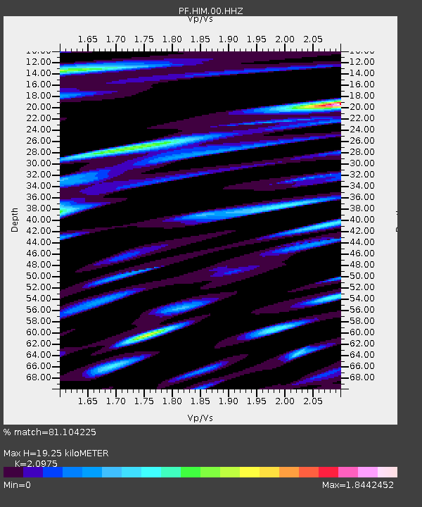
| Estimated Moho Depth: |
19.25 km |
| Estimated Crust Vp/Vs: |
2.10 |
| Assumed Crust Vp: |
4.73 km/s |
| Estimated Crust Vs: |
2.255 km/s |
| Estimated Crust Poisson's Ratio: |
0.35 |
|
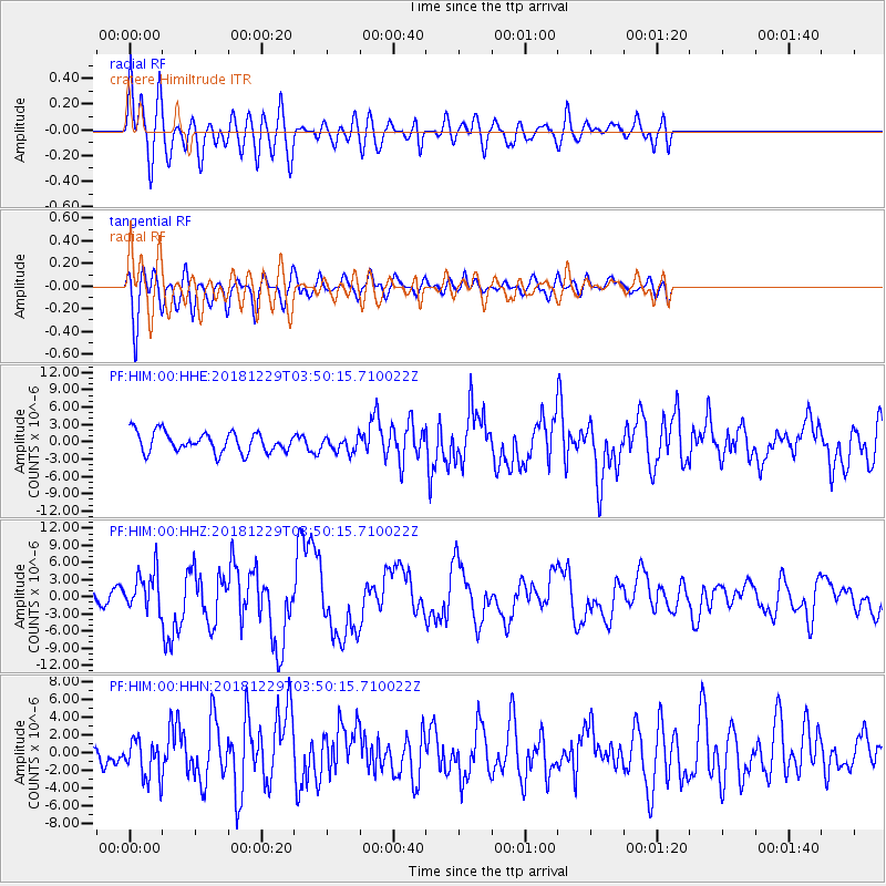
| Radial Match: |
81.104225 % |
| Radial Bump: |
400 |
| Transverse Match: |
73.98311 % |
| Transverse Bump: |
400 |
| SOD ConfigId: |
3201911 |
| Insert Time: |
2019-01-12 03:48:24.396 +0000 |
| GWidth: |
2.5 |
| Max Bumps: |
400 |
| Tol: |
0.001 |
|
Signal To Noise
| Channel | StoN | STA | LTA |
| PF:HIM:00:HHZ:20181229T03:50:15.710022Z | 4.4222746 | 3.3617682E-6 | 7.6018983E-7 |
| PF:HIM:00:HHN:20181229T03:50:15.710022Z | 1.4079016 | 2.157194E-6 | 1.5322051E-6 |
| PF:HIM:00:HHE:20181229T03:50:15.710022Z | 0.75942177 | 1.316537E-6 | 1.7336044E-6 |
| Arrivals |
| Ps | 4.5 SECOND |
| PpPs | 12 SECOND |
| PsPs/PpSs | 17 SECOND |


