You are here: Home > Network List > TX - Texas Seismological Network Stations List
> Station MB17 NE of Midland > Earthquake Result Viewer
MB17 NE of Midland - Earthquake Result Viewer
| Earthquake location: |
Near Coast Of Central Chile |
| Earthquake latitude/longitude: |
-30.3/-71.5 |
| Earthquake time(UTC): |
2023/09/06 (249) 23:48:05 GMT |
| Earthquake Depth: |
41 km |
| Earthquake Magnitude: |
6.2 mww |
| Earthquake Catalog/Contributor: |
NEIC PDE/us |
|
| Network: |
TX Texas Seismological Network |
| Station: |
MB17 NE of Midland |
| Lat/Lon: |
32.03 N/102.04 W |
| Elevation: |
852 m |
|
| Distance: |
68.4 deg |
| Az: |
332.372 deg |
| Baz: |
151.816 deg |
| Ray Param: |
0.056256738 |
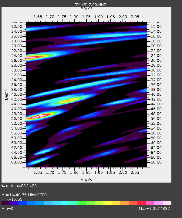
| Estimated Moho Depth: |
48.75 km |
| Estimated Crust Vp/Vs: |
1.65 |
| Assumed Crust Vp: |
6.129 km/s |
| Estimated Crust Vs: |
3.703 km/s |
| Estimated Crust Poisson's Ratio: |
0.21 |
|
| Radial Match: |
89.1483 % |
| Radial Bump: |
400 |
| Transverse Match: |
81.338905 % |
| Transverse Bump: |
400 |
| SOD ConfigId: |
31937991 |
| Insert Time: |
2023-09-21 00:19:12.568 +0000 |
| GWidth: |
2.5 |
| Max Bumps: |
400 |
| Tol: |
0.001 |
|

Signal To Noise
| Channel | StoN | STA | LTA |
| TX:MB17:00:HHZ:20230906T23:58:31.595982Z | 8.831218 | 1.812486E-7 | 2.0523624E-8 |
| TX:MB17:00:HHN:20230906T23:58:31.595982Z | 2.478506 | 3.8645744E-8 | 1.5592354E-8 |
| TX:MB17:00:HHE:20230906T23:58:31.595982Z | 3.6110513 | 5.551594E-8 | 1.53739E-8 |
| Arrivals |
| Ps | 5.4 SECOND |
| PpPs | 20 SECOND |
| PsPs/PpSs | 26 SECOND |


