You are here: Home > Network List > TA - USArray Transportable Network (new EarthScope stations) Stations List
> Station S37A Fort Scott, KS, USA > Earthquake Result Viewer
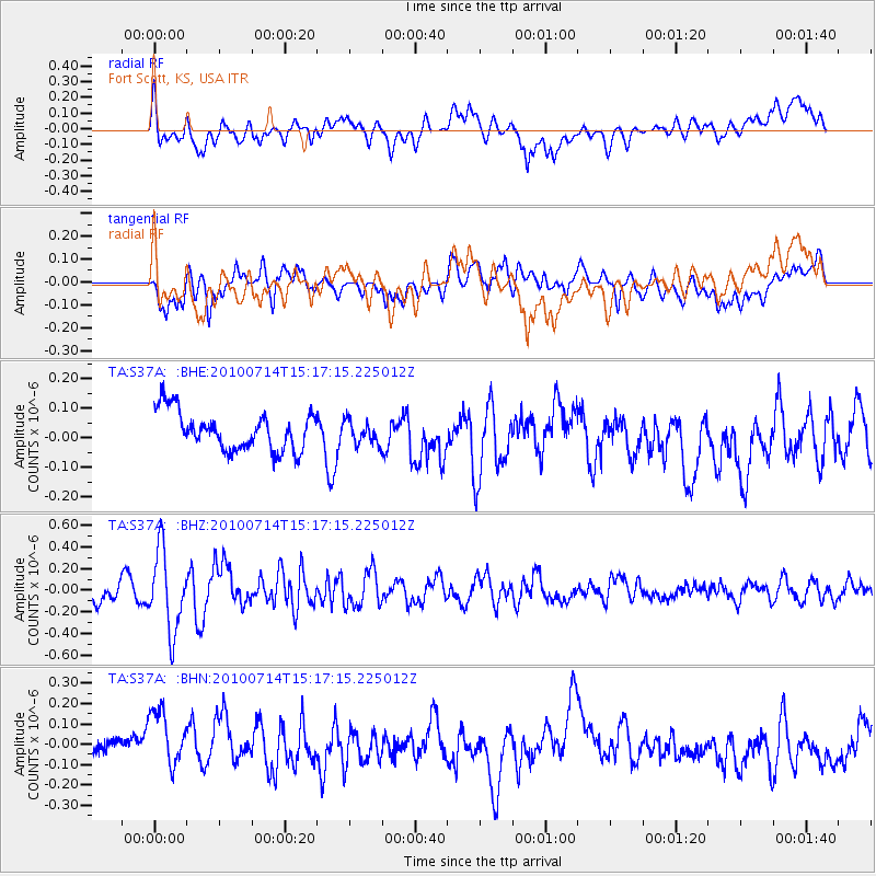
S37A Fort Scott, KS, USA - Earthquake Result Viewer
*The percent match for this event was below the threshold and hence no stack was calculated.
| Earthquake location: |
Near Coast Of Central Chile |
| Earthquake latitude/longitude: |
-38.2/-73.2 |
| Earthquake time(UTC): |
2010/07/14 (195) 15:05:50 GMT |
| Earthquake Depth: |
35 km |
| Earthquake Magnitude: |
5.5 MS, 5.4 MB, 5.8 MW, 5.7 MW |
| Earthquake Catalog/Contributor: |
WHDF/NEIC |
|
| Network: |
TA USArray Transportable Network (new EarthScope stations) |
| Station: |
S37A Fort Scott, KS, USA |
| Lat/Lon: |
37.76 N/94.83 W |
| Elevation: |
260 m |
|
| Distance: |
78.2 deg |
| Az: |
342.66 deg |
| Baz: |
162.771 deg |
| Ray Param: |
$rayparam |
*The percent match for this event was below the threshold and hence was not used in the summary stack. |
|
| Radial Match: |
70.18231 % |
| Radial Bump: |
400 |
| Transverse Match: |
51.893486 % |
| Transverse Bump: |
400 |
| SOD ConfigId: |
319893 |
| Insert Time: |
2011-01-05 04:39:40.485 +0000 |
| GWidth: |
2.5 |
| Max Bumps: |
400 |
| Tol: |
0.001 |
|
Signal To Noise
| Channel | StoN | STA | LTA |
| TA:S37A: :BHZ:20100714T15:17:15.225012Z | 4.9782434 | 3.6465005E-7 | 7.3248735E-8 |
| TA:S37A: :BHN:20100714T15:17:15.225012Z | 2.6112661 | 1.4446634E-7 | 5.532425E-8 |
| TA:S37A: :BHE:20100714T15:17:15.225012Z | 0.60761744 | 3.9333543E-8 | 6.473405E-8 |
| Arrivals |
| Ps | |
| PpPs | |
| PsPs/PpSs | |


