You are here: Home > Network List > UO - University of Oregon Regional Network Stations List
> Station VERN Vernonia Municipal Airport, Vernonia, OR, USA > Earthquake Result Viewer
VERN Vernonia Municipal Airport, Vernonia, OR, USA - Earthquake Result Viewer
| Earthquake location: |
Near Coast Of Central Chile |
| Earthquake latitude/longitude: |
-30.3/-71.5 |
| Earthquake time(UTC): |
2023/09/06 (249) 23:48:05 GMT |
| Earthquake Depth: |
41 km |
| Earthquake Magnitude: |
6.2 mww |
| Earthquake Catalog/Contributor: |
NEIC PDE/us |
|
| Network: |
UO University of Oregon Regional Network |
| Station: |
VERN Vernonia Municipal Airport, Vernonia, OR, USA |
| Lat/Lon: |
45.85 N/123.25 W |
| Elevation: |
198 m |
|
| Distance: |
89.1 deg |
| Az: |
326.726 deg |
| Baz: |
137.229 deg |
| Ray Param: |
0.042047434 |
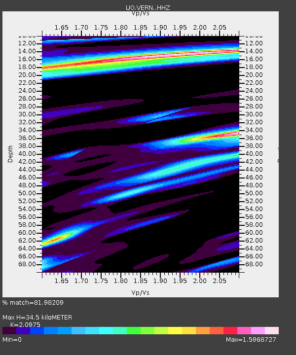
| Estimated Moho Depth: |
34.5 km |
| Estimated Crust Vp/Vs: |
2.10 |
| Assumed Crust Vp: |
6.566 km/s |
| Estimated Crust Vs: |
3.13 km/s |
| Estimated Crust Poisson's Ratio: |
0.35 |
|
| Radial Match: |
81.98209 % |
| Radial Bump: |
349 |
| Transverse Match: |
74.180504 % |
| Transverse Bump: |
400 |
| SOD ConfigId: |
31937991 |
| Insert Time: |
2023-09-21 00:21:35.012 +0000 |
| GWidth: |
2.5 |
| Max Bumps: |
400 |
| Tol: |
0.001 |
|

Signal To Noise
| Channel | StoN | STA | LTA |
| UO:VERN: :HHZ:20230907T00:00:24.740025Z | 6.815266 | 1.2185704E-6 | 1.7880012E-7 |
| UO:VERN: :HHN:20230907T00:00:24.740025Z | 1.0380604 | 2.8676604E-7 | 2.762518E-7 |
| UO:VERN: :HHE:20230907T00:00:24.740025Z | 1.872049 | 5.456712E-7 | 2.914834E-7 |
| Arrivals |
| Ps | 5.9 SECOND |
| PpPs | 16 SECOND |
| PsPs/PpSs | 22 SECOND |


