You are here: Home > Network List > UU - University of Utah Regional Network Stations List
> Station CCUT Cedar City, UT, USA > Earthquake Result Viewer
CCUT Cedar City, UT, USA - Earthquake Result Viewer
| Earthquake location: |
Near Coast Of Central Chile |
| Earthquake latitude/longitude: |
-30.3/-71.5 |
| Earthquake time(UTC): |
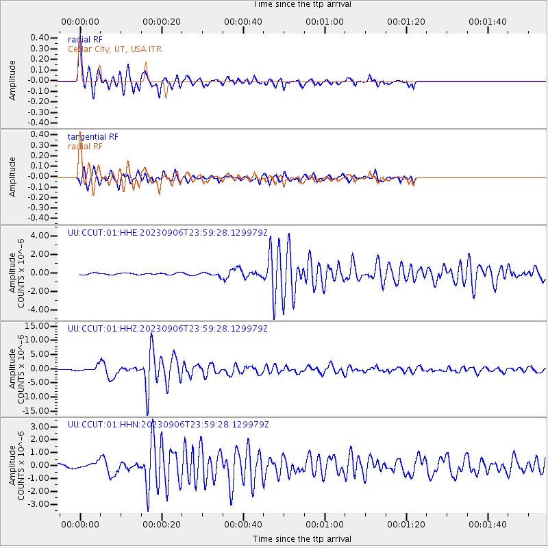
2023/09/06 (249) 23:48:05 GMT |
| Earthquake Depth: |
41 km |
| Earthquake Magnitude: |
6.2 mww |
| Earthquake Catalog/Contributor: |
NEIC PDE/us |
|
| Network: |
UU University of Utah Regional Network |
| Station: |
CCUT Cedar City, UT, USA |
| Lat/Lon: |
37.55 N/113.36 W |
| Elevation: |
2127 m |
|
| Distance: |
78.0 deg |
| Az: |
327.189 deg |
| Baz: |
143.859 deg |
| Ray Param: |
0.04988089 |
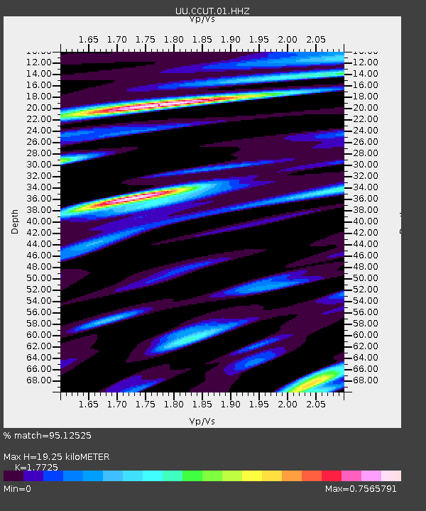
| Estimated Moho Depth: |
19.25 km |
| Estimated Crust Vp/Vs: |
1.77 |
| Assumed Crust Vp: |
6.194 km/s |
| Estimated Crust Vs: |
3.495 km/s |
| Estimated Crust Poisson's Ratio: |
0.27 |
|
| Radial Match: |
95.12525 % |
| Radial Bump: |
321 |
| Transverse Match: |
86.483826 % |
| Transverse Bump: |
382 |
| SOD ConfigId: |
31937991 |
| Insert Time: |
2023-09-21 00:23:07.617 +0000 |
| GWidth: |
2.5 |
| Max Bumps: |
400 |
| Tol: |
0.001 |
|
Signal To Noise
| Channel | StoN | STA | LTA |
| UU:CCUT:01:HHZ:20230906T23:59:28.129979Z | 10.190245 | 8.93325E-7 | 8.766473E-8 |
| UU:CCUT:01:HHN:20230906T23:59:28.129979Z | 1.6489793 | 2.5536565E-7 | 1.5486286E-7 |
| UU:CCUT:01:HHE:20230906T23:59:28.129979Z | 2.243992 | 1.9208333E-7 | 8.5598934E-8 |
| Arrivals |
| Ps | 2.5 SECOND |
| PpPs | 8.4 SECOND |
| PsPs/PpSs | 11 SECOND |


