You are here: Home > Network List > UW - Pacific Northwest Regional Seismic Network Stations List
> Station IRON Crane, OR, USA > Earthquake Result Viewer
IRON Crane, OR, USA - Earthquake Result Viewer
| Earthquake location: |
Near Coast Of Central Chile |
| Earthquake latitude/longitude: |
-30.3/-71.5 |
| Earthquake time(UTC): |
2023/09/06 (249) 23:48:05 GMT |
| Earthquake Depth: |
41 km |
| Earthquake Magnitude: |
6.2 mww |
| Earthquake Catalog/Contributor: |
NEIC PDE/us |
|
| Network: |
UW Pacific Northwest Regional Seismic Network |
| Station: |
IRON Crane, OR, USA |
| Lat/Lon: |
43.36 N/118.47 W |
| Elevation: |
1226 m |
|
| Distance: |
85.0 deg |
| Az: |
327.659 deg |
| Baz: |
140.619 deg |
| Ray Param: |
0.045038566 |
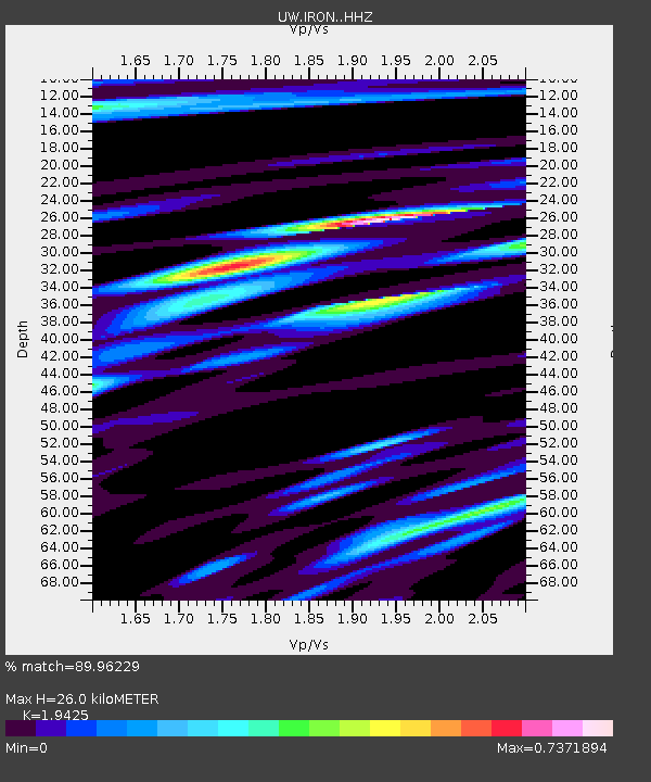
| Estimated Moho Depth: |
26.0 km |
| Estimated Crust Vp/Vs: |
1.94 |
| Assumed Crust Vp: |
6.279 km/s |
| Estimated Crust Vs: |
3.232 km/s |
| Estimated Crust Poisson's Ratio: |
0.32 |
|
| Radial Match: |
89.96229 % |
| Radial Bump: |
400 |
| Transverse Match: |
86.95739 % |
| Transverse Bump: |
400 |
| SOD ConfigId: |
31937991 |
| Insert Time: |
2023-09-21 00:25:29.314 +0000 |
| GWidth: |
2.5 |
| Max Bumps: |
400 |
| Tol: |
0.001 |
|
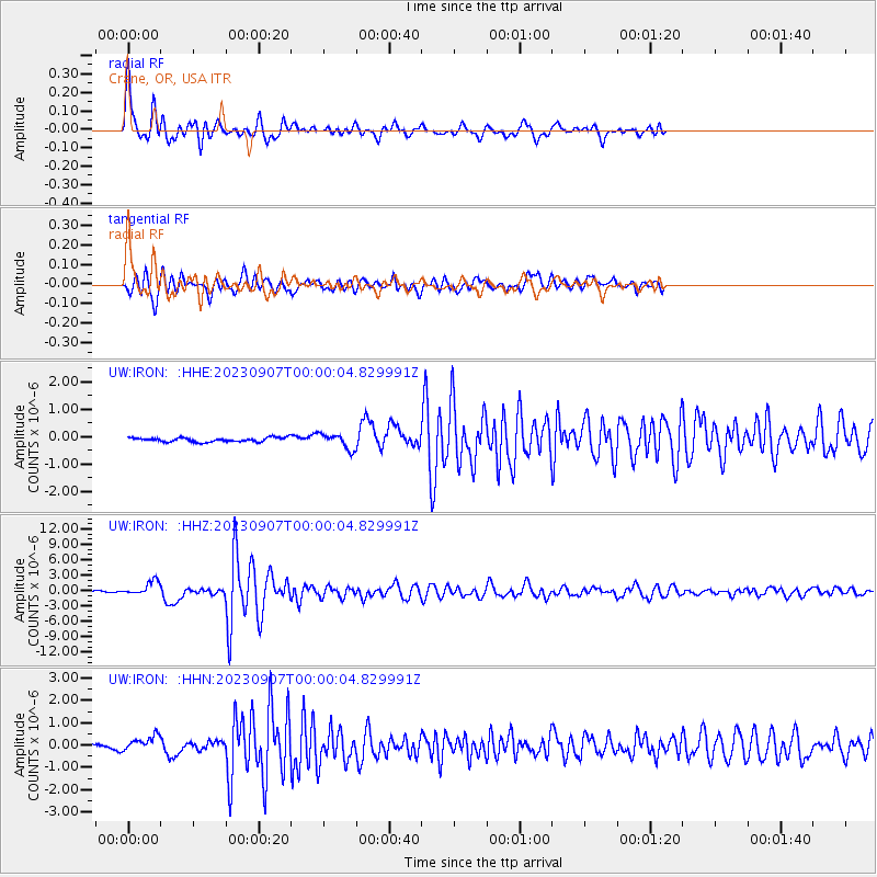
Signal To Noise
| Channel | StoN | STA | LTA |
| UW:IRON: :HHZ:20230907T00:00:04.829991Z | 13.008175 | 1.3633282E-6 | 1.048055E-7 |
| UW:IRON: :HHN:20230907T00:00:04.829991Z | 2.7806993 | 3.5004803E-7 | 1.258849E-7 |
| UW:IRON: :HHE:20230907T00:00:04.829991Z | 3.625095 | 2.7614078E-7 | 7.617477E-8 |
| Arrivals |
| Ps | 4.0 SECOND |
| PpPs | 12 SECOND |
| PsPs/PpSs | 16 SECOND |


