You are here: Home > Network List > WU - The Southern Ontario Seismic Network Stations List
> Station DELO Deloro Mine, Ontario, Canada > Earthquake Result Viewer
DELO Deloro Mine, Ontario, Canada - Earthquake Result Viewer
| Earthquake location: |
Near Coast Of Central Chile |
| Earthquake latitude/longitude: |
-30.3/-71.5 |
| Earthquake time(UTC): |
2023/09/06 (249) 23:48:05 GMT |
| Earthquake Depth: |
41 km |
| Earthquake Magnitude: |
6.2 mww |
| Earthquake Catalog/Contributor: |
NEIC PDE/us |
|
| Network: |
WU The Southern Ontario Seismic Network |
| Station: |
DELO Deloro Mine, Ontario, Canada |
| Lat/Lon: |
44.52 N/77.62 W |
| Elevation: |
213 m |
|
| Distance: |
74.6 deg |
| Az: |
355.491 deg |
| Baz: |
174.545 deg |
| Ray Param: |
0.052131318 |
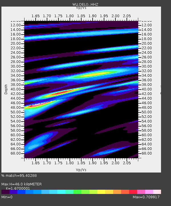
| Estimated Moho Depth: |
46.0 km |
| Estimated Crust Vp/Vs: |
1.67 |
| Assumed Crust Vp: |
6.577 km/s |
| Estimated Crust Vs: |
3.938 km/s |
| Estimated Crust Poisson's Ratio: |
0.22 |
|
| Radial Match: |
95.40288 % |
| Radial Bump: |
244 |
| Transverse Match: |
80.58874 % |
| Transverse Bump: |
400 |
| SOD ConfigId: |
31937991 |
| Insert Time: |
2023-09-21 00:29:00.094 +0000 |
| GWidth: |
2.5 |
| Max Bumps: |
400 |
| Tol: |
0.001 |
|

Signal To Noise
| Channel | StoN | STA | LTA |
| WU:DELO: :HHZ:20230906T23:59:09.134984Z | 28.687057 | 1.262862E-6 | 4.4022013E-8 |
| WU:DELO: :HHN:20230906T23:59:09.134984Z | 6.0498443 | 5.287157E-7 | 8.7393275E-8 |
| WU:DELO: :HHE:20230906T23:59:09.134984Z | 2.1731703 | 1.187809E-7 | 5.4657885E-8 |
| Arrivals |
| Ps | 4.9 SECOND |
| PpPs | 18 SECOND |
| PsPs/PpSs | 23 SECOND |


