You are here: Home > Network List > IW - Intermountain West Stations List
> Station MOOW Moose Ponds, Wyoming, USA > Earthquake Result Viewer
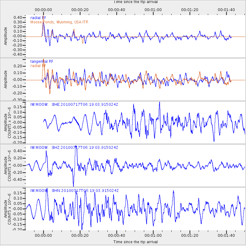
MOOW Moose Ponds, Wyoming, USA - Earthquake Result Viewer
*The percent match for this event was below the threshold and hence no stack was calculated.
| Earthquake location: |
Northern Chile |
| Earthquake latitude/longitude: |
-24.7/-69.8 |
| Earthquake time(UTC): |
2010/07/17 (198) 06:07:42 GMT |
| Earthquake Depth: |
49 km |
| Earthquake Magnitude: |
5.7 MB, 5.5 MW, 5.5 MW |
| Earthquake Catalog/Contributor: |
WHDF/NEIC |
|
| Network: |
IW Intermountain West |
| Station: |
MOOW Moose Ponds, Wyoming, USA |
| Lat/Lon: |
43.75 N/110.74 W |
| Elevation: |
2128 m |
|
| Distance: |
77.8 deg |
| Az: |
330.953 deg |
| Baz: |
142.462 deg |
| Ray Param: |
$rayparam |
*The percent match for this event was below the threshold and hence was not used in the summary stack. |
|
| Radial Match: |
66.53379 % |
| Radial Bump: |
400 |
| Transverse Match: |
60.851643 % |
| Transverse Bump: |
400 |
| SOD ConfigId: |
319893 |
| Insert Time: |
2011-01-05 04:47:12.498 +0000 |
| GWidth: |
2.5 |
| Max Bumps: |
400 |
| Tol: |
0.001 |
|
Signal To Noise
| Channel | StoN | STA | LTA |
| IW:MOOW: :BHZ:20100717T06:19:03.915024Z | 4.593447 | 1.9211082E-7 | 4.1822798E-8 |
| IW:MOOW: :BHN:20100717T06:19:03.915024Z | 2.1169403 | 9.562626E-8 | 4.5171923E-8 |
| IW:MOOW: :BHE:20100717T06:19:03.915024Z | 1.5725124 | 6.378485E-8 | 4.0562384E-8 |
| Arrivals |
| Ps | |
| PpPs | |
| PsPs/PpSs | |


