You are here: Home > Network List > CC - Cascade Chain Volcano Monitoring Stations List
> Station REM Rembrant, Mount St. Helens > Earthquake Result Viewer
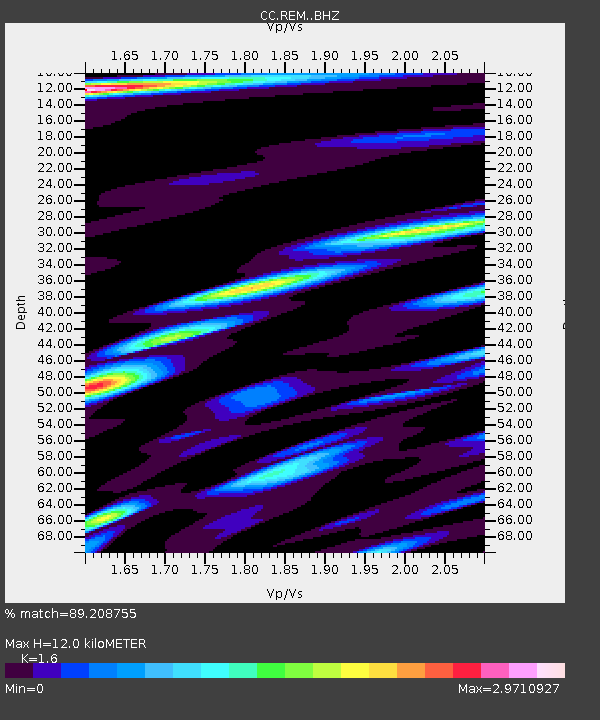
REM Rembrant, Mount St. Helens - Earthquake Result Viewer
| Earthquake location: |
South Of Kermadec Islands |
| Earthquake latitude/longitude: |
-33.3/-178.2 |
| Earthquake time(UTC): |
2023/09/08 (251) 09:09:50 GMT |
| Earthquake Depth: |
84 km |
| Earthquake Magnitude: |
6.6 Mi |
| Earthquake Catalog/Contributor: |
NEIC PDE/pt |
|
| Network: |
CC Cascade Chain Volcano Monitoring |
| Station: |
REM Rembrant, Mount St. Helens |
| Lat/Lon: |
46.20 N/122.19 W |
| Elevation: |
1905 m |
|
| Distance: |
93.9 deg |
| Az: |
35.263 deg |
| Baz: |
224.096 deg |
| Ray Param: |
0.04111206 |
| Estimated Moho Depth: |
12.0 km |
| Estimated Crust Vp/Vs: |
1.60 |
| Assumed Crust Vp: |
6.566 km/s |
| Estimated Crust Vs: |
4.104 km/s |
| Estimated Crust Poisson's Ratio: |
0.18 |
|
| Radial Match: |
89.208755 % |
| Radial Bump: |
400 |
| Transverse Match: |
79.15274 % |
| Transverse Bump: |
400 |
| SOD ConfigId: |
31937991 |
| Insert Time: |
2023-09-22 09:16:52.561 +0000 |
| GWidth: |
2.5 |
| Max Bumps: |
400 |
| Tol: |
0.001 |
|

Signal To Noise
| Channel | StoN | STA | LTA |
| CC:REM: :BHZ:20230908T09:22:27.059998Z | 1.215416 | 1.2785596E-7 | 1.0519523E-7 |
| CC:REM: :BHN:20230908T09:22:27.059998Z | 1.7976263 | 3.6228076E-7 | 2.0153287E-7 |
| CC:REM: :BHE:20230908T09:22:27.059998Z | 0.80388576 | 2.153406E-7 | 2.6787464E-7 |
| Arrivals |
| Ps | 1.1 SECOND |
| PpPs | 4.6 SECOND |
| PsPs/PpSs | 5.8 SECOND |


