You are here: Home > Network List > CC - Cascade Chain Volcano Monitoring Stations List
> Station STD Studebaker Ridge, Mount St. Helens > Earthquake Result Viewer
STD Studebaker Ridge, Mount St. Helens - Earthquake Result Viewer
| Earthquake location: |
South Of Kermadec Islands |
| Earthquake latitude/longitude: |
-33.3/-178.2 |
| Earthquake time(UTC): |
2023/09/08 (251) 09:09:50 GMT |
| Earthquake Depth: |
84 km |
| Earthquake Magnitude: |
6.6 Mi |
| Earthquake Catalog/Contributor: |
NEIC PDE/pt |
|
| Network: |
CC Cascade Chain Volcano Monitoring |
| Station: |
STD Studebaker Ridge, Mount St. Helens |
| Lat/Lon: |
46.24 N/122.22 W |
| Elevation: |
1189 m |
|
| Distance: |
93.9 deg |
| Az: |
35.218 deg |
| Baz: |
224.071 deg |
| Ray Param: |
0.041110218 |
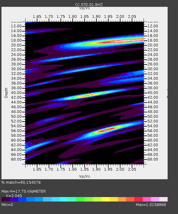
| Estimated Moho Depth: |
17.75 km |
| Estimated Crust Vp/Vs: |
2.05 |
| Assumed Crust Vp: |
6.566 km/s |
| Estimated Crust Vs: |
3.211 km/s |
| Estimated Crust Poisson's Ratio: |
0.34 |
|
| Radial Match: |
90.154076 % |
| Radial Bump: |
400 |
| Transverse Match: |
84.26897 % |
| Transverse Bump: |
400 |
| SOD ConfigId: |
31937991 |
| Insert Time: |
2023-09-22 09:16:55.885 +0000 |
| GWidth: |
2.5 |
| Max Bumps: |
400 |
| Tol: |
0.001 |
|

Signal To Noise
| Channel | StoN | STA | LTA |
| CC:STD:01:BHZ:20230908T09:22:27.099976Z | 0.41366172 | 4.1990447E-8 | 1.0150915E-7 |
| CC:STD:01:BHN:20230908T09:22:27.099976Z | 2.410222 | 1.3666609E-7 | 5.6702696E-8 |
| CC:STD:01:BHE:20230908T09:22:27.099976Z | 1.7484652 | 1.1789428E-7 | 6.7427294E-8 |
| Arrivals |
| Ps | 2.9 SECOND |
| PpPs | 8.1 SECOND |
| PsPs/PpSs | 11 SECOND |


