You are here: Home > Network List > CC - Cascade Chain Volcano Monitoring Stations List
> Station UNFR Upper North Fork Repeater > Earthquake Result Viewer
UNFR Upper North Fork Repeater - Earthquake Result Viewer
| Earthquake location: |
South Of Kermadec Islands |
| Earthquake latitude/longitude: |
-33.3/-178.2 |
| Earthquake time(UTC): |
2023/09/08 (251) 09:09:50 GMT |
| Earthquake Depth: |
84 km |
| Earthquake Magnitude: |
6.6 Mi |
| Earthquake Catalog/Contributor: |
NEIC PDE/pt |
|
| Network: |
CC Cascade Chain Volcano Monitoring |
| Station: |
UNFR Upper North Fork Repeater |
| Lat/Lon: |
46.27 N/122.29 W |
| Elevation: |
884 m |
|
| Distance: |
93.9 deg |
| Az: |
35.16 deg |
| Baz: |
224.026 deg |
| Ray Param: |
0.04111193 |
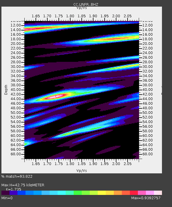
| Estimated Moho Depth: |
42.75 km |
| Estimated Crust Vp/Vs: |
1.74 |
| Assumed Crust Vp: |
6.566 km/s |
| Estimated Crust Vs: |
3.785 km/s |
| Estimated Crust Poisson's Ratio: |
0.25 |
|
| Radial Match: |
93.822 % |
| Radial Bump: |
378 |
| Transverse Match: |
85.87495 % |
| Transverse Bump: |
394 |
| SOD ConfigId: |
31937991 |
| Insert Time: |
2023-09-22 09:17:02.659 +0000 |
| GWidth: |
2.5 |
| Max Bumps: |
400 |
| Tol: |
0.001 |
|

Signal To Noise
| Channel | StoN | STA | LTA |
| CC:UNFR: :BHZ:20230908T09:22:27.059998Z | 0.59740853 | 4.9470174E-8 | 8.2807944E-8 |
| CC:UNFR: :BHN:20230908T09:22:27.059998Z | 2.094615 | 1.4332805E-7 | 6.8426914E-8 |
| CC:UNFR: :BHE:20230908T09:22:27.059998Z | 1.0273752 | 8.81246E-8 | 8.5776456E-8 |
| Arrivals |
| Ps | 4.9 SECOND |
| PpPs | 17 SECOND |
| PsPs/PpSs | 22 SECOND |


