You are here: Home > Network List > UU - University of Utah Regional Network Stations List
> Station FORU South Mineral Mountains, UT, USA > Earthquake Result Viewer
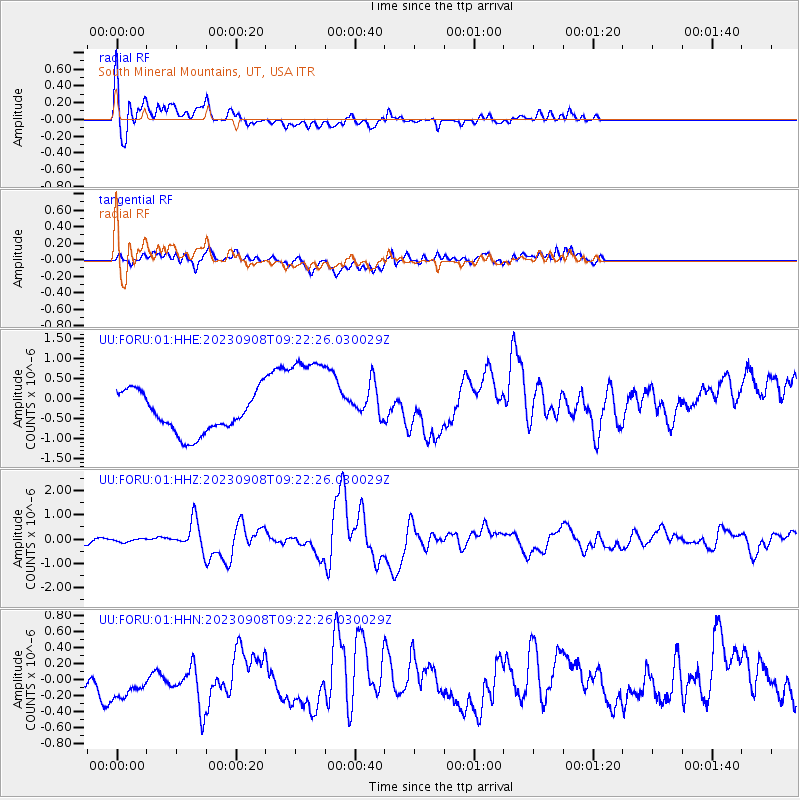
FORU South Mineral Mountains, UT, USA - Earthquake Result Viewer
*The percent match for this event was below the threshold and hence no stack was calculated.
| Earthquake location: |
South Of Kermadec Islands |
| Earthquake latitude/longitude: |
-33.3/-178.2 |
| Earthquake time(UTC): |
2023/09/08 (251) 09:09:50 GMT |
| Earthquake Depth: |
84 km |
| Earthquake Magnitude: |
6.6 Mi |
| Earthquake Catalog/Contributor: |
NEIC PDE/pt |
|
| Network: |
UU University of Utah Regional Network |
| Station: |
FORU South Mineral Mountains, UT, USA |
| Lat/Lon: |
38.46 N/112.86 W |
| Elevation: |
1840 m |
|
| Distance: |
93.7 deg |
| Az: |
45.645 deg |
| Baz: |
229.68 deg |
| Ray Param: |
$rayparam |
*The percent match for this event was below the threshold and hence was not used in the summary stack. |
|
| Radial Match: |
52.410183 % |
| Radial Bump: |
400 |
| Transverse Match: |
29.974499 % |
| Transverse Bump: |
400 |
| SOD ConfigId: |
31937991 |
| Insert Time: |
2023-09-22 09:27:03.844 +0000 |
| GWidth: |
2.5 |
| Max Bumps: |
400 |
| Tol: |
0.001 |
|
Signal To Noise
| Channel | StoN | STA | LTA |
| UU:FORU:01:HHZ:20230908T09:22:26.030029Z | 0.5525982 | 7.074116E-8 | 1.2801554E-7 |
| UU:FORU:01:HHN:20230908T09:22:26.030029Z | 2.8037004 | 2.4828998E-7 | 8.8557954E-8 |
| UU:FORU:01:HHE:20230908T09:22:26.030029Z | 2.5691457 | 1.2651263E-6 | 4.924308E-7 |
| Arrivals |
| Ps | |
| PpPs | |
| PsPs/PpSs | |


