You are here: Home > Network List > TA - USArray Transportable Network (new EarthScope stations) Stations List
> Station H20A Greybull, WY, USA > Earthquake Result Viewer
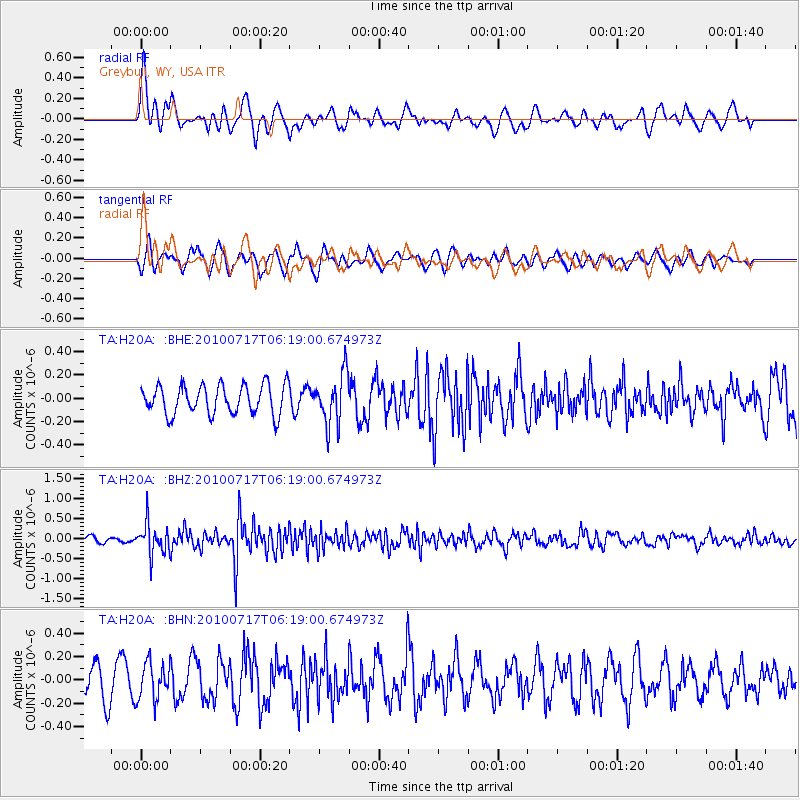
H20A Greybull, WY, USA - Earthquake Result Viewer
*The percent match for this event was below the threshold and hence no stack was calculated.
| Earthquake location: |
Northern Chile |
| Earthquake latitude/longitude: |
-24.7/-69.8 |
| Earthquake time(UTC): |
2010/07/17 (198) 06:07:42 GMT |
| Earthquake Depth: |
49 km |
| Earthquake Magnitude: |
5.7 MB, 5.5 MW, 5.5 MW |
| Earthquake Catalog/Contributor: |
WHDF/NEIC |
|
| Network: |
TA USArray Transportable Network (new EarthScope stations) |
| Station: |
H20A Greybull, WY, USA |
| Lat/Lon: |
44.49 N/108.00 W |
| Elevation: |
1236 m |
|
| Distance: |
77.2 deg |
| Az: |
333.032 deg |
| Baz: |
144.817 deg |
| Ray Param: |
$rayparam |
*The percent match for this event was below the threshold and hence was not used in the summary stack. |
|
| Radial Match: |
59.0541 % |
| Radial Bump: |
368 |
| Transverse Match: |
66.6862 % |
| Transverse Bump: |
400 |
| SOD ConfigId: |
319893 |
| Insert Time: |
2011-01-05 04:50:29.071 +0000 |
| GWidth: |
2.5 |
| Max Bumps: |
400 |
| Tol: |
0.001 |
|
Signal To Noise
| Channel | StoN | STA | LTA |
| TA:H20A: :BHZ:20100717T06:19:00.674973Z | 5.2330284 | 3.8877744E-7 | 7.4293006E-8 |
| TA:H20A: :BHN:20100717T06:19:00.674973Z | 1.3970317 | 1.5746474E-7 | 1.1271379E-7 |
| TA:H20A: :BHE:20100717T06:19:00.674973Z | 1.723215 | 2.1697201E-7 | 1.2591117E-7 |
| Arrivals |
| Ps | |
| PpPs | |
| PsPs/PpSs | |


