You are here: Home > Network List > AE - Arizona Broadband Seismic Network Stations List
> Station X18A Snowflake, AZ, USA > Earthquake Result Viewer
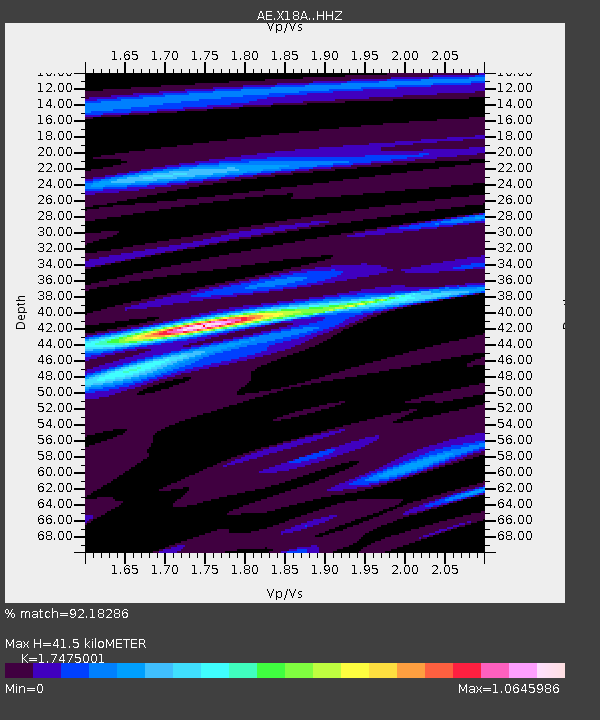
X18A Snowflake, AZ, USA - Earthquake Result Viewer
| Earthquake location: |
South Of Kermadec Islands |
| Earthquake latitude/longitude: |
-32.7/-179.3 |
| Earthquake time(UTC): |
2023/09/08 (251) 09:09:58 GMT |
| Earthquake Depth: |
90 km |
| Earthquake Magnitude: |
6.6 mww |
| Earthquake Catalog/Contributor: |
NEIC PDE/us |
|
| Network: |
AE Arizona Broadband Seismic Network |
| Station: |
X18A Snowflake, AZ, USA |
| Lat/Lon: |
34.53 N/109.95 W |
| Elevation: |
1751 m |
|
| Distance: |
93.3 deg |
| Az: |
50.707 deg |
| Baz: |
232.199 deg |
| Ray Param: |
0.04123882 |
| Estimated Moho Depth: |
41.5 km |
| Estimated Crust Vp/Vs: |
1.75 |
| Assumed Crust Vp: |
6.496 km/s |
| Estimated Crust Vs: |
3.717 km/s |
| Estimated Crust Poisson's Ratio: |
0.26 |
|
| Radial Match: |
92.18286 % |
| Radial Bump: |
398 |
| Transverse Match: |
76.5831 % |
| Transverse Bump: |
400 |
| SOD ConfigId: |
31937991 |
| Insert Time: |
2023-09-22 09:29:41.634 +0000 |
| GWidth: |
2.5 |
| Max Bumps: |
400 |
| Tol: |
0.001 |
|

Signal To Noise
| Channel | StoN | STA | LTA |
| AE:X18A: :HHZ:20230908T09:22:32.139991Z | 12.594476 | 1.1972916E-6 | 9.506482E-8 |
| AE:X18A: :HHN:20230908T09:22:32.139991Z | 1.8660923 | 1.9351323E-7 | 1.03699705E-7 |
| AE:X18A: :HHE:20230908T09:22:32.139991Z | 4.579206 | 3.596752E-7 | 7.854532E-8 |
| Arrivals |
| Ps | 4.9 SECOND |
| PpPs | 17 SECOND |
| PsPs/PpSs | 22 SECOND |


