You are here: Home > Network List > TA - USArray Transportable Network (new EarthScope stations) Stations List
> Station I20A Worland, WY, USA > Earthquake Result Viewer
I20A Worland, WY, USA - Earthquake Result Viewer
*The percent match for this event was below the threshold and hence no stack was calculated.
| Earthquake location: |
Northern Chile |
| Earthquake latitude/longitude: |
-24.7/-69.8 |
| Earthquake time(UTC): |
2010/07/17 (198) 06:07:42 GMT |
| Earthquake Depth: |
49 km |
| Earthquake Magnitude: |
5.7 MB, 5.5 MW, 5.5 MW |
| Earthquake Catalog/Contributor: |
WHDF/NEIC |
|
| Network: |
TA USArray Transportable Network (new EarthScope stations) |
| Station: |
I20A Worland, WY, USA |
| Lat/Lon: |
43.95 N/108.13 W |
| Elevation: |
1342 m |
|
| Distance: |
76.8 deg |
| Az: |
332.636 deg |
| Baz: |
144.638 deg |
| Ray Param: |
$rayparam |
*The percent match for this event was below the threshold and hence was not used in the summary stack. |
|
| Radial Match: |
45.21091 % |
| Radial Bump: |
369 |
| Transverse Match: |
68.98669 % |
| Transverse Bump: |
400 |
| SOD ConfigId: |
319893 |
| Insert Time: |
2011-01-05 04:50:40.831 +0000 |
| GWidth: |
2.5 |
| Max Bumps: |
400 |
| Tol: |
0.001 |
|
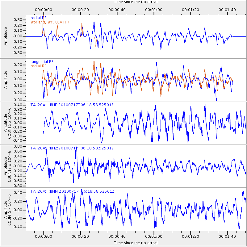
Signal To Noise
| Channel | StoN | STA | LTA |
| TA:I20A: :BHZ:20100717T06:18:58.52501Z | 2.1209052 | 2.9994996E-7 | 1.4142545E-7 |
| TA:I20A: :BHN:20100717T06:18:58.52501Z | 0.6152061 | 9.489521E-8 | 1.5424946E-7 |
| TA:I20A: :BHE:20100717T06:18:58.52501Z | 1.9330516 | 2.4955744E-7 | 1.2910024E-7 |
| Arrivals |
| Ps | |
| PpPs | |
| PsPs/PpSs | |


