You are here: Home > Network List > TA - USArray Transportable Network (new EarthScope stations) Stations List
> Station A21A Bergtoll Ranch, Theony, MT, USA > Earthquake Result Viewer
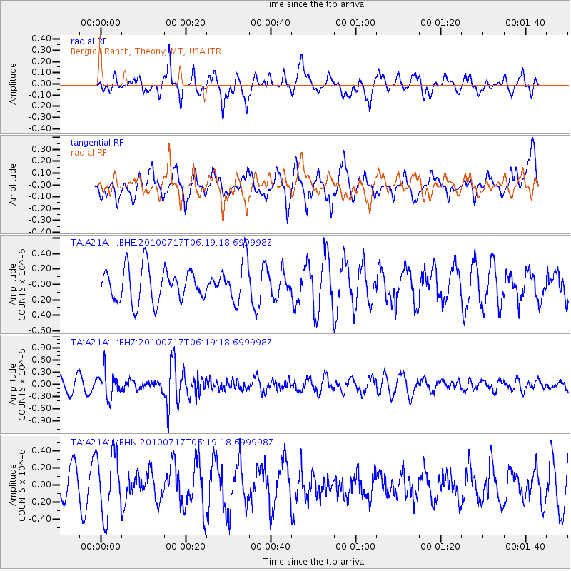
A21A Bergtoll Ranch, Theony, MT, USA - Earthquake Result Viewer
*The percent match for this event was below the threshold and hence no stack was calculated.
| Earthquake location: |
Northern Chile |
| Earthquake latitude/longitude: |
-24.7/-69.8 |
| Earthquake time(UTC): |
2010/07/17 (198) 06:07:42 GMT |
| Earthquake Depth: |
49 km |
| Earthquake Magnitude: |
5.7 MB, 5.5 MW, 5.5 MW |
| Earthquake Catalog/Contributor: |
WHDF/NEIC |
|
| Network: |
TA USArray Transportable Network (new EarthScope stations) |
| Station: |
A21A Bergtoll Ranch, Theony, MT, USA |
| Lat/Lon: |
48.99 N/106.93 W |
| Elevation: |
779 m |
|
| Distance: |
80.5 deg |
| Az: |
336.252 deg |
| Baz: |
146.22 deg |
| Ray Param: |
$rayparam |
*The percent match for this event was below the threshold and hence was not used in the summary stack. |
|
| Radial Match: |
54.18632 % |
| Radial Bump: |
400 |
| Transverse Match: |
36.097298 % |
| Transverse Bump: |
379 |
| SOD ConfigId: |
319893 |
| Insert Time: |
2011-01-05 04:52:17.404 +0000 |
| GWidth: |
2.5 |
| Max Bumps: |
400 |
| Tol: |
0.001 |
|
Signal To Noise
| Channel | StoN | STA | LTA |
| TA:A21A: :BHZ:20100717T06:19:18.699998Z | 1.7005901 | 3.1273018E-7 | 1.8389508E-7 |
| TA:A21A: :BHN:20100717T06:19:18.699998Z | 2.990495 | 3.5938135E-7 | 1.2017453E-7 |
| TA:A21A: :BHE:20100717T06:19:18.699998Z | 1.345965 | 2.901674E-7 | 2.1558317E-7 |
| Arrivals |
| Ps | |
| PpPs | |
| PsPs/PpSs | |


